IMAGES TAKEN NEAR TO
Langleigh, Danescroft, LETCHWORTH GARDEN CITY, SG6 4RR
Introduction
This page details the photographs taken nearby to Langleigh, Danescroft, SG6 4RR by members of the Geograph project.
The Geograph project started in 2005 with the aim of publishing, organising and preserving representative images for every square kilometre of Great Britain, Ireland and the Isle of Man.

There are currently over 7.5m images from over14,400 individuals and you can help contribute to the project by visiting https://www.geograph.org.uk
Image Map
Images are licensed for reuse under creativecommons.org/licenses/by-sa/2.0
Notes
- Clicking on the map will re-center to the selected point.
- The higher the marker number, the further away the image location is from the centre of the postcode.
Image Listing (23 Images Found)
Images are licensed for reuse under creativecommons.org/licenses/by-sa/2.0
Image
Details
Distance
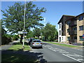
1

Northfield Infants School.
In the same enclosure as Grange Junior School.
Image: © Robin Hall
Taken: 14 Jan 2006
0.06 miles

4
Grange Baptist Church
A busy little church standing near a pub in the middle of the estate.
Image: © Robin Hall
Taken: 14 Jan 2006
0.07 miles
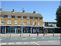
7
Southfields, Letchworth
Looking north west.
Image: © JThomas
Taken: 10 Jun 2017
0.12 miles
8
Post Office on Southfields, Letchworth
Showing position of Postbox No. SG6 286.
See Image] for postbox.
Image: © JThomas
Taken: 10 Jun 2017
0.12 miles
9
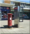
Elizabeth II postbox and telephone kiosk on Southfields, Letchworth
Outside the Post Office.
Postbox No. SG6 286.
See Image] for context.
Image: © JThomas
Taken: 10 Jun 2017
0.12 miles
10
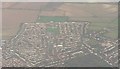
Northern Letchworth: an aerial view
This view, taken on a flight from Belfast to Stansted, graphically interprets the map of this square and, partly, the next square west. Individual roads can be identified on the map.
Looking at the hedge that starts centre-top of picture and proceeds diagonally right, you can see where the public footpath on the map continues through the field in the same direction when the hedge comes to an end.
Image: © Chris Downer
Taken: 12 Nov 2007
0.13 miles