IMAGES TAKEN NEAR TO
Lawrence Avenue, LETCHWORTH GARDEN CITY, SG6 2EY
Introduction
This page details the photographs taken nearby to Lawrence Avenue, SG6 2EY by members of the Geograph project.
The Geograph project started in 2005 with the aim of publishing, organising and preserving representative images for every square kilometre of Great Britain, Ireland and the Isle of Man.

There are currently over 7.5m images from over14,400 individuals and you can help contribute to the project by visiting https://www.geograph.org.uk
Image Map
Images are licensed for reuse under creativecommons.org/licenses/by-sa/2.0
Notes
- Clicking on the map will re-center to the selected point.
- The higher the marker number, the further away the image location is from the centre of the postcode.
Image Listing (12 Images Found)
Images are licensed for reuse under creativecommons.org/licenses/by-sa/2.0
Image
Details
Distance
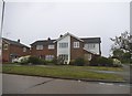
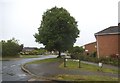
2
Waysbrook at the corner of Lordship Lane
Image: © David Howard
Taken: 12 May 2018
0.15 miles
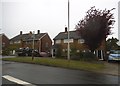
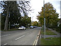
3
Lordship Lane at the corner of Howard Drive
Image: © David Howard
Taken: 12 May 2018
0.18 miles
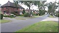
4
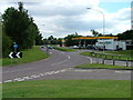
The garage on the "Longabout"
Commonly known locally as the longabout because it is a long stretched out roundabout. Simple as that.
Image: © Robin Hall
Taken: 29 Jul 2005
0.18 miles
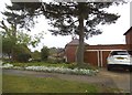
5
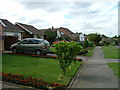
Waysbrook
Just off the longabout. Slightly upmarket in the general scheme of things.
Image: © Robin Hall
Taken: 29 Jul 2005
0.18 miles
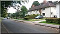
7
South end of Norton Way South, Letchworth
From near the junction with Baldock Road (behind the photographer).
Image: © Richard Vince
Taken: 10 Oct 2020
0.20 miles
8
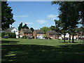
Houses on Waysbrook, Letchworth
Looking over a green.
Image: © JThomas
Taken: 10 Jun 2017
0.20 miles