IMAGES TAKEN NEAR TO
Roxley Manor, LETCHWORTH GARDEN CITY, SG6 2DP
Introduction
This page details the photographs taken nearby to Roxley Manor, SG6 2DP by members of the Geograph project.
The Geograph project started in 2005 with the aim of publishing, organising and preserving representative images for every square kilometre of Great Britain, Ireland and the Isle of Man.

There are currently over 7.5m images from over14,400 individuals and you can help contribute to the project by visiting https://www.geograph.org.uk
Image Map
Images are licensed for reuse under creativecommons.org/licenses/by-sa/2.0
Notes
- Clicking on the map will re-center to the selected point.
- The higher the marker number, the further away the image location is from the centre of the postcode.
Image Listing (9 Images Found)
Images are licensed for reuse under creativecommons.org/licenses/by-sa/2.0
Image
Details
Distance
1
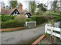
The Lodge, Roxley Court, Willian
Roxley Court has been a house, a convent, a care home, and is now apartments.
Image: © Humphrey Bolton
Taken: 10 Mar 2020
0.08 miles
2
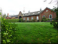
Former stable block, Roxley Court, Willian
This is now divided into houses.
Image: © Humphrey Bolton
Taken: 10 Mar 2020
0.09 miles
3
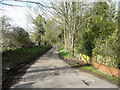
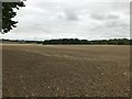
Roxley Court Lane, Willian
This as part of the Sustrans Route 12.
Image: © Humphrey Bolton
Taken: 10 Mar 2020
0.09 miles
4
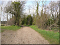
Sustrans Route 12 approaching Roxley Court Lane, Willian
Image: © Humphrey Bolton
Taken: 10 Mar 2020
0.12 miles
6
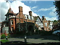
Roxley Court.
Was a convent. Now rather swanky apartments.
Image: © Robin Hall
Taken: 28 Jul 2005
0.18 miles

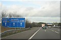
9
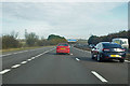
A1(M) northbound
Approaching junction 9.
Image: © Robin Webster
Taken: 17 Feb 2018
0.21 miles