IMAGES TAKEN NEAR TO
Alder Green, HITCHIN, SG5 4RX
Introduction
This page details the photographs taken nearby to Alder Green, SG5 4RX by members of the Geograph project.
The Geograph project started in 2005 with the aim of publishing, organising and preserving representative images for every square kilometre of Great Britain, Ireland and the Isle of Man.

There are currently over 7.5m images from over14,400 individuals and you can help contribute to the project by visiting https://www.geograph.org.uk
Image Map (Loading...)


Getting Data...Please wait
Leaflet Map data © OpenStreetMap
Images are licensed for reuse under creativecommons.org/licenses/by-sa/2.0
Notes
- Clicking on the map will re-center to the selected point.
- The higher the marker number, the further away the image location is from the centre of the postcode.
Image Listing (11 Images Found)
Images are licensed for reuse under creativecommons.org/licenses/by-sa/2.0
Image
Details
Distance
1

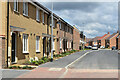
Newly-built street: Blackthorn Place, Stotfold
Stotfold is subject to substantial residential expansion. Here, a newly-completed street on the very edge of the village, with open land just visible on the right.
Image: © David Martin
Taken: 29 May 2022
0.05 miles
2
Newly-built street: Elder Avenue, Stotfold
Stotfold is subject to substantial residential expansion. Here, a newly-completed street on the east of the village.
Image: © David Martin
Taken: 29 May 2022
0.15 miles
3

Newly-built street: Elder Avenue, Stotfold
Stotfold is subject to substantial residential expansion. Here, a newly-completed street on the east of the village.
Image: © David Martin
Taken: 29 May 2022
0.15 miles

6
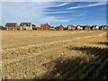
New housing on the northern edge of Stotfold
Image: © Philip Jeffrey
Taken: 7 Aug 2022
0.22 miles
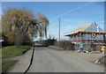
8
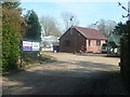
The River Ivel Nursery, Stotfold
I was curious as to what the cluster of little buildings on the 'Explorer' map is, and it turned out to be a plant nursery with greenhouses.
Image: © Humphrey Bolton
Taken: 21 Mar 2018
0.23 miles
9
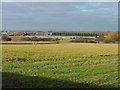
Nursery near the A1(M).
These vast greenhouses adjacent to the M1 probabbly look more impressive from the air.
Image: © Robin Hall
Taken: 25 Dec 2005
0.24 miles
10
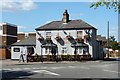
The Crown, Stotfold
At the north end of Regent Street.
Image: © Robin Webster
Taken: 6 Sep 2015
0.24 miles