IMAGES TAKEN NEAR TO
Baldock Road, HITCHIN, SG5 4NZ
Introduction
This page details the photographs taken nearby to Baldock Road, SG5 4NZ by members of the Geograph project.
The Geograph project started in 2005 with the aim of publishing, organising and preserving representative images for every square kilometre of Great Britain, Ireland and the Isle of Man.

There are currently over 7.5m images from over14,400 individuals and you can help contribute to the project by visiting https://www.geograph.org.uk
Image Map (Loading...)


Getting Data...Please wait
Leaflet Map data © OpenStreetMap
Images are licensed for reuse under creativecommons.org/licenses/by-sa/2.0
Notes
- Clicking on the map will re-center to the selected point.
- The higher the marker number, the further away the image location is from the centre of the postcode.
Image Listing (54 Images Found)
Images are licensed for reuse under creativecommons.org/licenses/by-sa/2.0
Image
Details
Distance
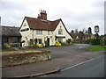
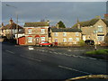
1
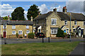
Houses on the corner of Queen Street, Stotfold
Image: © David Martin
Taken: 6 Aug 2021
0.08 miles
2
Houses seen across small triangular green at Stotfold
Image: © David Martin
Taken: 6 Aug 2021
0.08 miles
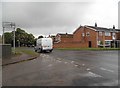
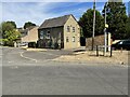
4
Groveland Way at the junction of Norton Road
Image: © David Howard
Taken: 12 May 2018
0.09 miles
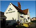
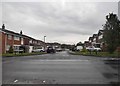
5
Stotfold - Willowherb Way
Modern housing development.
Image: © James Emmans
Taken: 13 Feb 2017
0.10 miles
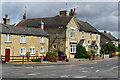
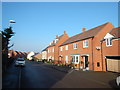
6
Two tiny houses in Stotfold.
These two small houses are not big enough to swing a cat in (unless it is a very small cat and you have short arms).
Image: © Robin Hall
Taken: 25 Dec 2005
0.10 miles