IMAGES TAKEN NEAR TO
Faraday Gardens, HITCHIN, SG5 4FW
Introduction
This page details the photographs taken nearby to Faraday Gardens, SG5 4FW by members of the Geograph project.
The Geograph project started in 2005 with the aim of publishing, organising and preserving representative images for every square kilometre of Great Britain, Ireland and the Isle of Man.

There are currently over 7.5m images from over14,400 individuals and you can help contribute to the project by visiting https://www.geograph.org.uk
Image Map (Loading...)


Getting Data...Please wait
Leaflet Map data © OpenStreetMap
Images are licensed for reuse under creativecommons.org/licenses/by-sa/2.0
Notes
- Clicking on the map will re-center to the selected point.
- The higher the marker number, the further away the image location is from the centre of the postcode.
Image Listing (5 Images Found)
Images are licensed for reuse under creativecommons.org/licenses/by-sa/2.0
Image
Details
Distance
1
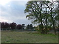
Fairfield Park
This dull and uninspiring photo is of the site of the old London Chest Hospital. On the 1940's map you can see a crescent shaped building which had open but covered verandas where patients suffering from TB would be wheeled into the cold air to get better. Later this was used as a psychiatric hospital but with the closure of the large hospitals in the 1990's the land was bought up for development. Work is still in progress.
Image: © Robin Hall
Taken: 30 Oct 2005
0.12 miles
2

The Blue Lagoon at Letchworth Garden City
The larger of the two, a flooded pit; the smaller one is the Green Lagoon. The housing estate on the right is Fairfield, and Arlesey is on the left.
Image: © M J Richardson
Taken: 26 Jun 2015
0.16 miles
3
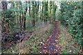
Footpath out of Fairfield into the woods
Image: © Philip Jeffrey
Taken: 30 Oct 2022
0.19 miles
4
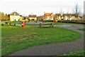
Play area by Dickens Boulevard Fairfield
Image: © Philip Jeffrey
Taken: 30 Oct 2022
0.22 miles