IMAGES TAKEN NEAR TO
Astwick Road, HITCHIN, SG5 4BQ
Introduction
This page details the photographs taken nearby to Astwick Road, SG5 4BQ by members of the Geograph project.
The Geograph project started in 2005 with the aim of publishing, organising and preserving representative images for every square kilometre of Great Britain, Ireland and the Isle of Man.

There are currently over 7.5m images from over14,400 individuals and you can help contribute to the project by visiting https://www.geograph.org.uk
Image Map (34 Images)


Leaflet Map data © OpenStreetMap
Images are licensed for reuse under creativecommons.org/licenses/by-sa/2.0
Notes
- Clicking on the map will re-center to the selected point.
- The higher the marker number, the further away the image location is from the centre of the postcode.
Image Listing (34 Images Found)
Images are licensed for reuse under creativecommons.org/licenses/by-sa/2.0
Image
Details
Distance
3
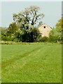
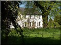
Old Kitchen Garden Bowman's Mill, Astwick
Image: © Dylan Mills
Taken: 24 Apr 2009
0.15 miles
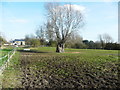
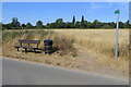
8
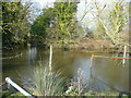
A corner of the moat, Astwick
Cattle and horses can drink here.
Image: © Humphrey Bolton
Taken: 21 Mar 2018
0.17 miles
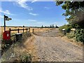
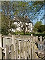
9

Bowman's Mill Astwick
Watermill under restoration to become luxury hotel.
Image: © Dylan Mills
Taken: 24 Apr 2009
0.19 miles