IMAGES TAKEN NEAR TO
The Green, HITCHIN, SG5 4AN
Introduction
This page details the photographs taken nearby to The Green, SG5 4AN by members of the Geograph project.
The Geograph project started in 2005 with the aim of publishing, organising and preserving representative images for every square kilometre of Great Britain, Ireland and the Isle of Man.

There are currently over 7.5m images from over14,400 individuals and you can help contribute to the project by visiting https://www.geograph.org.uk
Image Map (Loading...)


Getting Data...Please wait
Leaflet Map data © OpenStreetMap
Images are licensed for reuse under creativecommons.org/licenses/by-sa/2.0
Notes
- Clicking on the map will re-center to the selected point.
- The higher the marker number, the further away the image location is from the centre of the postcode.
Image Listing (22 Images Found)
Images are licensed for reuse under creativecommons.org/licenses/by-sa/2.0
Image
Details
Distance
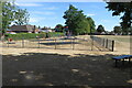
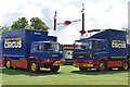
1
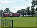
Funfair vehicles, Stotfold Green
It looks as if they are about to set up.
Image: © Robin Webster
Taken: 6 Sep 2015
0.03 miles
3

King's Baptist Church Stotfold.
Someone has designed this church with some iron or steel components high up on the copper spire. The result....
Image: © Robin Hall
Taken: 25 Dec 2005
0.06 miles