IMAGES TAKEN NEAR TO
Ickleford Mews, HITCHIN, SG5 3YL
Introduction
This page details the photographs taken nearby to Ickleford Mews, SG5 3YL by members of the Geograph project.
The Geograph project started in 2005 with the aim of publishing, organising and preserving representative images for every square kilometre of Great Britain, Ireland and the Isle of Man.

There are currently over 7.5m images from over14,400 individuals and you can help contribute to the project by visiting https://www.geograph.org.uk
Image Map (Loading...)


Getting Data...Please wait
Leaflet Map data © OpenStreetMap
Images are licensed for reuse under creativecommons.org/licenses/by-sa/2.0
Notes
- Clicking on the map will re-center to the selected point.
- The higher the marker number, the further away the image location is from the centre of the postcode.
Image Listing (17 Images Found)
Images are licensed for reuse under creativecommons.org/licenses/by-sa/2.0
Image
Details
Distance
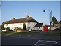
3
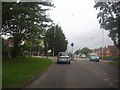
Mini roundabout on Bedford Road, Ickleford
Image: © David Howard
Taken: 31 May 2012
0.05 miles
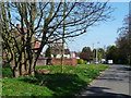
4
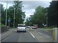
The junction of Bedford Road and Turnpike Lane
Image: © David Howard
Taken: 31 May 2012
0.05 miles

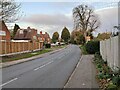
8

Sheltered housing in Ickleford
This is in the built up part of this square, in a rather uninspiring estate.
Image: © Robin Hall
Taken: 29 Oct 2005
0.12 miles

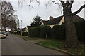
10
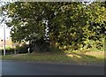
Westmill Lane, Ickleford
The tree marks the end of the row of houses along the north side of the lane from Bedford Road.
Image: © Humphrey Bolton
Taken: 14 Apr 2015
0.15 miles