IMAGES TAKEN NEAR TO
Freewaters Close, HITCHIN, SG5 3TQ
Introduction
This page details the photographs taken nearby to Freewaters Close, SG5 3TQ by members of the Geograph project.
The Geograph project started in 2005 with the aim of publishing, organising and preserving representative images for every square kilometre of Great Britain, Ireland and the Isle of Man.

There are currently over 7.5m images from over14,400 individuals and you can help contribute to the project by visiting https://www.geograph.org.uk
Image Map (Loading...)


Getting Data...Please wait
Leaflet Map data © OpenStreetMap
Images are licensed for reuse under creativecommons.org/licenses/by-sa/2.0
Notes
- Clicking on the map will re-center to the selected point.
- The higher the marker number, the further away the image location is from the centre of the postcode.
Image Listing (73 Images Found)
Images are licensed for reuse under creativecommons.org/licenses/by-sa/2.0
Image
Details
Distance
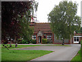
1
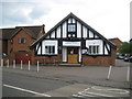
Ickleford Village Hall
Built in 1925 and with the refurbishment works photographed in 2008 in Image now complete.
Image: © Nigel Cox
Taken: 13 Jun 2010
0.04 miles
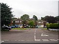
3
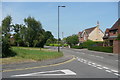
Arlesey Road at Witter Avenue
A public footpath goes to the left.
Image: © Humphrey Bolton
Taken: 14 Jun 2017
0.06 miles
4
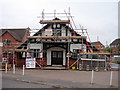
Ickleford Village Hall
Being refurbished.
Image: © John Lucas
Taken: 18 Jul 2008
0.09 miles
5
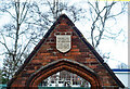
Ickleford : school gateway plaque
The gateway is Grade II listed - details at https://historicengland.org.uk/listing/the-list/list-entry/1295724?section=official-list-entry.
Image: © Jim Osley
Taken: 23 Feb 2023
0.09 miles
7
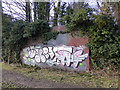
Abutment of ex-Midland Railway bridge
On the Midland Railway branch from Hitchin to Bedford which closed in 1964. Unfortunately defaced by brain-dead morons.
Image: © John Lucas
Taken: 27 Feb 2014
0.10 miles
8
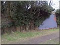
Railway Workings Near Gerry's Hole
Gerry's hole is a large pond formed by the construction of railway. The railway itself is now almost completely gone. You can see the odd clue here and there such as this brick wall. It looks like it would have been part of a bridge for the railway.
http://www.icklefordpc.com/html/gerry_s_hole.html
Image: © Robert Matin
Taken: 21 Mar 2011
0.10 miles
9
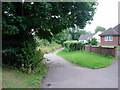
Track at Ickleford
This insignificant looking track forms part of the Icknield Way, said to be the oldest road in Britain, extending from Ivinghoe Beacon in Buckinghamshire to Knettishall Heath in Norfolk, it consists of prehistoric pathways, ancient even when the Romans came. http://www.icknieldwaypath.co.uk/
Image: © John Lucas
Taken: 18 Jul 2008
0.10 miles
10
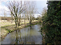
River Oughton
Viewed from a footbridge which carries the Icknield Way across the river.
Image: © John Lucas
Taken: 27 Feb 2014
0.11 miles