IMAGES TAKEN NEAR TO
Hillfoot Road, HITCHIN, SG5 3NH
Introduction
This page details the photographs taken nearby to Hillfoot Road, SG5 3NH by members of the Geograph project.
The Geograph project started in 2005 with the aim of publishing, organising and preserving representative images for every square kilometre of Great Britain, Ireland and the Isle of Man.

There are currently over 7.5m images from over14,400 individuals and you can help contribute to the project by visiting https://www.geograph.org.uk
Image Map
Images are licensed for reuse under creativecommons.org/licenses/by-sa/2.0
Notes
- Clicking on the map will re-center to the selected point.
- The higher the marker number, the further away the image location is from the centre of the postcode.
Image Listing (52 Images Found)
Images are licensed for reuse under creativecommons.org/licenses/by-sa/2.0
Image
Details
Distance
1
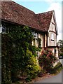
Timber-framed house, Church Street, Shillington
According to the listing details, this building was built in the 17C, and has been the Five Bells public house.
Image: © Humphrey Bolton
Taken: 12 Sep 2017
0.07 miles
2
Timber-framed house, Church Street, Shillington
Image: © Jim Osley
Taken: 25 Jul 2015
0.09 miles

6
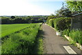
John Bunyan Trail going down to Hillfoot End
Image: © Philip Jeffrey
Taken: 30 May 2021
0.11 miles

9
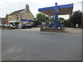
Shillington 's Local service station
B.V.Bowles garage and service
Image: © Raymond Cubberley
Taken: 21 Jul 2012
0.13 miles