IMAGES TAKEN NEAR TO
High Road, HITCHIN, SG5 3LU
Introduction
This page details the photographs taken nearby to High Road, SG5 3LU by members of the Geograph project.
The Geograph project started in 2005 with the aim of publishing, organising and preserving representative images for every square kilometre of Great Britain, Ireland and the Isle of Man.

There are currently over 7.5m images from over14,400 individuals and you can help contribute to the project by visiting https://www.geograph.org.uk
Image Map
Images are licensed for reuse under creativecommons.org/licenses/by-sa/2.0
Notes
- Clicking on the map will re-center to the selected point.
- The higher the marker number, the further away the image location is from the centre of the postcode.
Image Listing (22 Images Found)
Images are licensed for reuse under creativecommons.org/licenses/by-sa/2.0
Image
Details
Distance
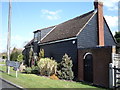
1
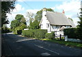
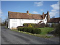
Thatched cottage, Apsley End, Shillington
Grade II listed, and built in the late 17C and 18C according to the listing details.
Image: © Humphrey Bolton
Taken: 12 Sep 2017
0.01 miles
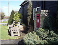
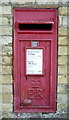
2
Postbox, Apsley End
At the 61 metre spot height, by the four-way road junction.
Image: © Christine Johnstone
Taken: 30 Oct 2014
0.04 miles
3
Elizabeth II postbox, Apsley End
Image: © JThomas
Taken: 25 Mar 2016
0.04 miles
4
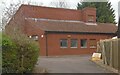
Shillington Telephone Exchange
This redbrick TE is in High Road, Apsley End SG5 3LU and would appear to date from the early 1980s when it replaced the former TEs in Pirton and Shillington. It has the code SMSGN and provides telephone and broadband services to Gravenhurst, Holwell, Pirton and Shillington plus the surrounding rural area. The numbering range of this TE is (01462) 71xxxx, the (01462) referring to the Hitchin group of ten TEs. A yellow grit salt bin can be seen in front of the TE.
Image: © David Hillas
Taken: 16 Mar 2024
0.04 miles
5
Close up, Elizabeth II postbox, Apsley End
Postbox No. SG5 85.
See Image] for postbox.
Image: © JThomas
Taken: 25 Mar 2016
0.04 miles
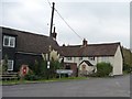
6
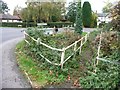
Overgrown footbridge and stream, Apsley End
At the four-way road junction in the centre of the hamlet.
Image: © Christine Johnstone
Taken: 30 Oct 2014
0.05 miles
7
House, Apsley End
Showing position of Postbox No. SG5 85.
See Image] for postbox.
Image: © JThomas
Taken: 25 Mar 2016
0.05 miles
8
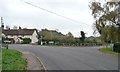
Four-way road junction, Apsley End
In effect, an X-shaped crossroads bisected by a stream.
Image: © Christine Johnstone
Taken: 30 Oct 2014
0.05 miles
10
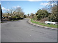
Hanscombe End Road, Shillington
Looking north west, Apsley End.
Image: © JThomas
Taken: 25 Mar 2016
0.06 miles