IMAGES TAKEN NEAR TO
Stondon Road, HITCHIN, SG5 3HG
Introduction
This page details the photographs taken nearby to Stondon Road, SG5 3HG by members of the Geograph project.
The Geograph project started in 2005 with the aim of publishing, organising and preserving representative images for every square kilometre of Great Britain, Ireland and the Isle of Man.

There are currently over 7.5m images from over14,400 individuals and you can help contribute to the project by visiting https://www.geograph.org.uk
Image Map
Images are licensed for reuse under creativecommons.org/licenses/by-sa/2.0
Notes
- Clicking on the map will re-center to the selected point.
- The higher the marker number, the further away the image location is from the centre of the postcode.
Image Listing (9 Images Found)
Images are licensed for reuse under creativecommons.org/licenses/by-sa/2.0
Image
Details
Distance
2
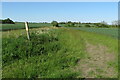
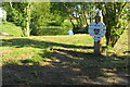
Gate and defunct stile on the footpath by Chibley Farm
Image: © Philip Jeffrey
Taken: 30 May 2021
0.15 miles
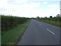
6

Track, Bridleway and Footpath between arable fields near Mayfield farm
Looking south-eastward.
Image: © Peter Wood
Taken: 10 Oct 2021
0.18 miles
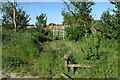
8
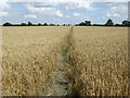
Footpath to Chibley Farm
Heads north east over a crop field from Shillington Road.
Image: © JThomas
Taken: 15 Aug 2015
0.24 miles