IMAGES TAKEN NEAR TO
Bedford Road, HITCHIN, SG5 2UQ
Introduction
This page details the photographs taken nearby to Bedford Road, SG5 2UQ by members of the Geograph project.
The Geograph project started in 2005 with the aim of publishing, organising and preserving representative images for every square kilometre of Great Britain, Ireland and the Isle of Man.

There are currently over 7.5m images from over14,400 individuals and you can help contribute to the project by visiting https://www.geograph.org.uk
Image Map
Images are licensed for reuse under creativecommons.org/licenses/by-sa/2.0
Notes
- Clicking on the map will re-center to the selected point.
- The higher the marker number, the further away the image location is from the centre of the postcode.
Image Listing (6 Images Found)
Images are licensed for reuse under creativecommons.org/licenses/by-sa/2.0
Image
Details
Distance


3

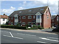
Westmill Estate
Playground and typical housing. The Westmill estate is a mix of this type of housing, low rise flats and blocks up to 5 storeys.
Image: © Robin Hall
Taken: 26 Jul 2005
0.20 miles
5
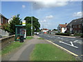
Bus stop and shelter on Bedford Road (A600)
Looking north.
Image: © JThomas
Taken: 15 Aug 2015
0.22 miles
6
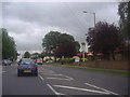
Bedford Road approaching Bearton Road, Hitchin
The Angel's Reply pub is on the right
Image: © David Howard
Taken: 31 May 2012
0.24 miles