IMAGES TAKEN NEAR TO
Swinburne Avenue, HITCHIN, SG5 2RL
Introduction
This page details the photographs taken nearby to Swinburne Avenue, SG5 2RL by members of the Geograph project.
The Geograph project started in 2005 with the aim of publishing, organising and preserving representative images for every square kilometre of Great Britain, Ireland and the Isle of Man.

There are currently over 7.5m images from over14,400 individuals and you can help contribute to the project by visiting https://www.geograph.org.uk
Image Map (Loading...)


Getting Data...Please wait
Leaflet Map data © OpenStreetMap
Images are licensed for reuse under creativecommons.org/licenses/by-sa/2.0
Notes
- Clicking on the map will re-center to the selected point.
- The higher the marker number, the further away the image location is from the centre of the postcode.
Image Listing (19 Images Found)
Images are licensed for reuse under creativecommons.org/licenses/by-sa/2.0
Image
Details
Distance
2
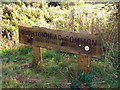
Oughtonhead Common
Local Nature Reserve.
Image: © John Lucas
Taken: 20 Sep 2006
0.15 miles
3
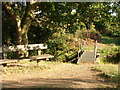
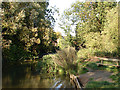
Bridge and seat on Oughtonhead Common
The bridge allows access across a tributary of the River Oughton and forms part of a network of footpaths on the common.
Image: © John Lucas
Taken: 20 Sep 2006
0.15 miles
4
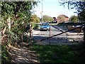
Gate and pinch stile, West Mill
To provide access to West Mill from West Mill Lane.
Image: © John Lucas
Taken: 20 Sep 2006
0.15 miles
5
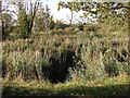
Reeds, Oughtonhead Common
On the River Oughton.
Image: © John Lucas
Taken: 20 Sep 2006
0.15 miles
6
River Oughton at Oughtonhead Common
From the Hertfordshire Countryside Magazine, April 1967:-
The Lucas family was closely associated with Oughton Head and owned much of the land around the common. William Lucas in his diary tells of his favourite walk out over Gaping Hills to Orton (sic) Head; Samuel Lucas drew and painted the countryside and birds; and Francis Lucas wrote poems which reflect the scene of fields and woods around and the men who worked them. They also helped shape the present aspects of Oughton Head as the following extracts from William Lucas's diary [A Quaker Diary, Published by Hutchinson & Co, 1933] show:
11th Month 7th, 1842: "Met the Leet Jury at Orton Head Common and they marked out a piece of ground to be given up to us in lieu of the cartway from the lane to our seven-acre piece. This piece I intend to plant"
12th Month 5th, 1842: "Finished planting my new clump at Orton Head. The ladies have all taken their share. J. Lister planted all the Poplars, Christiana Lucas all the Chestnuts, Sarah Lucas the Mountain Ash and Phebe Lucas the Abel Poplars."
12th Month 24th, 1843: "... and I have been planting Elms about Orton Head and Hungry Hill, also the small piece of land taken from the common, which should be called Ladies' Copse"
Image: © John Lucas
Taken: 20 Sep 2006
0.17 miles
7
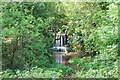
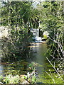
Waterfall at Oughtonhead Common Nature Reserve
Man made waterfall on the River Oughton just along from the dog paddling pool!
Image: © Robert Matin
Taken: 25 May 2009
0.17 miles
9
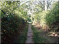
Footpath at West Mill
Leading from the West Mill housing estate to Oughtonhead Common.
Image: © John Lucas
Taken: 20 Sep 2006
0.18 miles
10
Overflow weir on the River Oughton
The river is dammed to power a former mill, and this appears to be an overflow weir, seen here with telephoto from the restricted byway. The river upstream looks very still, so I am surprised that there is so much flow over the weir.
Image: © Humphrey Bolton
Taken: 14 Apr 2015
0.18 miles