IMAGES TAKEN NEAR TO
Friday Furlong, HITCHIN, SG5 2ND
Introduction
This page details the photographs taken nearby to Friday Furlong, SG5 2ND by members of the Geograph project.
The Geograph project started in 2005 with the aim of publishing, organising and preserving representative images for every square kilometre of Great Britain, Ireland and the Isle of Man.

There are currently over 7.5m images from over14,400 individuals and you can help contribute to the project by visiting https://www.geograph.org.uk
Image Map (Loading...)


Getting Data...Please wait
Leaflet Map data © OpenStreetMap
Images are licensed for reuse under creativecommons.org/licenses/by-sa/2.0
Notes
- Clicking on the map will re-center to the selected point.
- The higher the marker number, the further away the image location is from the centre of the postcode.
Image Listing (6 Images Found)
Images are licensed for reuse under creativecommons.org/licenses/by-sa/2.0
Image
Details
Distance
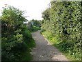
1
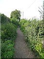
Lucas Lane, Hitchin
This is part of the footpath section of the lane. The path is fringed by vegetation that looks attractive at first sight but includes clumps of nettles.
Image: © Humphrey Bolton
Taken: 22 Sep 2010
0.08 miles
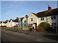
2
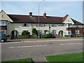
Houses, Redhill Road, Hitchin
Houses like these, with arches over twin doorways and tile-hung bay windows, occur frequently in the Westmill estate.
Image: © Humphrey Bolton
Taken: 22 Sep 2010
0.10 miles
3
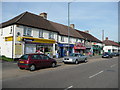
Shops, Redhill Road, Hitchin
This road leads to the Westmill council estate. They are lucky to have a post office so near to the town centre.
Image: © Humphrey Bolton
Taken: 22 Sep 2010
0.18 miles
4
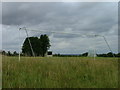
Hitchin Cricket and Hockey Club
Occasional site for testimonial matches featuring professionals - but not often. These are not hockey goals - obviously
Image: © Robin Hall
Taken: 26 Jul 2005
0.19 miles
5
Lucas Lane, Hitchin
Here the lane passes a resiedential static caravan site.
Image: © Humphrey Bolton
Taken: 22 Sep 2010
0.20 miles
6
Mattocke Road
1930s council houses in Westmill.
Image: © Burgess Von Thunen
Taken: 20 Jan 2014
0.21 miles