IMAGES TAKEN NEAR TO
Crow Furlong, HITCHIN, SG5 2HW
Introduction
This page details the photographs taken nearby to Crow Furlong, SG5 2HW by members of the Geograph project.
The Geograph project started in 2005 with the aim of publishing, organising and preserving representative images for every square kilometre of Great Britain, Ireland and the Isle of Man.

There are currently over 7.5m images from over14,400 individuals and you can help contribute to the project by visiting https://www.geograph.org.uk
Image Map
Images are licensed for reuse under creativecommons.org/licenses/by-sa/2.0
Notes
- Clicking on the map will re-center to the selected point.
- The higher the marker number, the further away the image location is from the centre of the postcode.
Image Listing (15 Images Found)
Images are licensed for reuse under creativecommons.org/licenses/by-sa/2.0
Image
Details
Distance
1
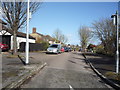
High View, Hitchin
Looking north from Pirton Road.
Image: © JThomas
Taken: 25 Mar 2016
0.06 miles
2

Elizabeth II postbox on Pirton Road
Image: © JThomas
Taken: 25 Mar 2016
0.09 miles
3

Close up, Elizabeth II postbox on Pirton Road
Postbox No. SG5 10.
See Image] for postbox.
Image: © JThomas
Taken: 25 Mar 2016
0.09 miles
4

Pirton Road (B655)
Looking west showing position of Postbox No. SG5 10.
See Image] for postbox.
Image: © JThomas
Taken: 25 Mar 2016
0.09 miles
5

Farmland at Mount Pleasant beside the Pirton Road
George Beaver, the first Hitchin Surveyor, recorded in his journal that on 12th Feb 1820, a post windmill owned by the Lucas family was successfully moved from a site to the south of the Mount Pleasant Plantation to a new location on Gaping Hills, above Oughtonhead Farm, a distance of some 450 yards. The windmill was moved intact, complete with stones, on a specially constructed four-wheeled frame, pulled by 36 horses in six rows of six abreast. Local schoolboys were given the day off to watch the proceedings.
Viewing contemporary maps and inspection of the landscape, the area in the foreground of this view, a small plateau, is most likey the original location of the windmill. See Image for a view of a possible new location.
Image: © John Lucas
Taken: 25 Apr 2013
0.10 miles
6

Mount Pleasant at the junction of Pirton Road
Mount Pleasant is the name of the adjacent hill on the west side of the road.
Image: © David Howard
Taken: 12 May 2018
0.11 miles
7
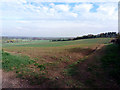
Fields above Oughtonhead Farm
The area in the foreground of this view is a possible location of the Lucas windmill after it had been moved from south of the Mount Pleasant Plantation. See Image The windmill survived until circa 1850. The reasons for the move and its eventual demise are unknown.
Image: © John Lucas
Taken: 25 Apr 2013
0.14 miles
8
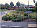
Lucas Lane, Hitchin
Named after the Quaker family which was prominent in the town for more than 3 centuries. The building in view is the 'Lavender Fields' Cheshire Home. It is named in recognition of the lavender industry which was so important in the town and of which some remnants still survive.
Image: © John Lucas
Taken: 19 Sep 2007
0.14 miles