IMAGES TAKEN NEAR TO
Strathmore Avenue, HITCHIN, SG5 1SL
Introduction
This page details the photographs taken nearby to Strathmore Avenue, SG5 1SL by members of the Geograph project.
The Geograph project started in 2005 with the aim of publishing, organising and preserving representative images for every square kilometre of Great Britain, Ireland and the Isle of Man.

There are currently over 7.5m images from over14,400 individuals and you can help contribute to the project by visiting https://www.geograph.org.uk
Image Map (Loading...)


Getting Data...Please wait
Leaflet Map data © OpenStreetMap
Images are licensed for reuse under creativecommons.org/licenses/by-sa/2.0
Notes
- Clicking on the map will re-center to the selected point.
- The higher the marker number, the further away the image location is from the centre of the postcode.
Image Listing (21 Images Found)
Images are licensed for reuse under creativecommons.org/licenses/by-sa/2.0
Image
Details
Distance
1
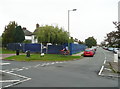
Building site, Strathmore Avenue, Hitchin
The site fencing is around a redevelopment to replace a house and some lock-up garages by two semi-detached houses.
Image: © Humphrey Bolton
Taken: 26 Sep 2017
0.05 miles
2
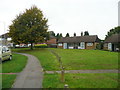
Council bungalows, Periwinkle Lane, Hitchin
These look out onto a pleasant strip of grass. The car parked on the grass on the left explains why the wooden posts are necessary.
Image: © Humphrey Bolton
Taken: 26 Sep 2017
0.06 miles
3
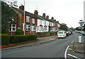
Periwinkle Lane, Hitchin
Not quite as rural as the name suggests.
Image: © Humphrey Bolton
Taken: 26 Sep 2017
0.06 miles
5
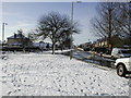
Old Hale Way
Looking south towards Bearton Road
Image: © Nick
Taken: 30 Jan 2003
0.19 miles

7
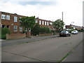
Hitchin: Heathfield Road
The terraced houses on the east side of Heathfield Road have an unusual flat roof design with the end ones in each block having a V-shaped front extension with double aspect windows. There was a major gas explosion in one of these houses, not in the photograph, in June 2008 which caused severe structural damage.
Image: © Nigel Cox
Taken: 13 Jun 2010
0.21 miles
8
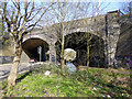
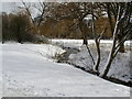
Grove Road rail bridge
The River Hiz arch.
Image: © John Lucas
Taken: 27 Feb 2014
0.23 miles
9
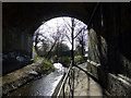
Grove Road rail bridge
The walkway beside the River Hiz.
Image: © John Lucas
Taken: 27 Feb 2014
0.23 miles
10
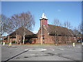
Church of Our Lady Immaculate and St Andrew Roman Catholic Church
Image: © JThomas
Taken: 25 Mar 2016
0.23 miles