IMAGES TAKEN NEAR TO
Lancaster Road, HITCHIN, SG5 1PE
Introduction
This page details the photographs taken nearby to Lancaster Road, SG5 1PE by members of the Geograph project.
The Geograph project started in 2005 with the aim of publishing, organising and preserving representative images for every square kilometre of Great Britain, Ireland and the Isle of Man.

There are currently over 7.5m images from over14,400 individuals and you can help contribute to the project by visiting https://www.geograph.org.uk
Image Map
Images are licensed for reuse under creativecommons.org/licenses/by-sa/2.0
Notes
- Clicking on the map will re-center to the selected point.
- The higher the marker number, the further away the image location is from the centre of the postcode.
Image Listing (19 Images Found)
Images are licensed for reuse under creativecommons.org/licenses/by-sa/2.0
Image
Details
Distance
1

Footpath in Hitchin
This footpath connects Fishpond Road with Duke's Lane. It has some history and is shown on the 1898 1:2500 County Series map.
Image: © John Lucas
Taken: 19 Sep 2007
0.12 miles
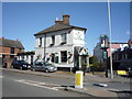
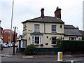
2
The Victoria, Hitchin
Staple Greene King hostelry
Image: © al partington
Taken: 15 Nov 2007
0.18 miles
3

Former Bus Garage, Hitchin
Taken in September 2007, this photo shows the former bus garage in Fishponds Road SG5 1NP which was originally used by United Counties Omnibus Co Ltd to operate services from Hitchin. Latterly, it had been used by Arriva until it was closed in the mid-2000s with vehicles being transferred to Stevenage nearby. Since then, it has been used as a hand car wash depot then demolished, housing now occupying this site.
Image: © David Hillas
Taken: 22 Sep 2007
0.19 miles
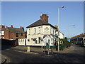
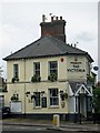
6
The Victoria
At 1 Ickleford Road, Hitchin. The earliest reference of a pub here was in 1864 when it was a beerhouse known as The Cricketers. It became a tied house of The Biggleswade Brewery until 1898 when the assets of that brewery were sold, and is now part of the Greene King empire.
Image: © John Lucas
Taken: 24 Sep 2008
0.21 miles
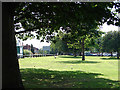
7

Butts Close, Hitchin
Looking towards the Leisure Centre, Fishpond's Road on the left
Image: © John Lucas
Taken: 19 Jul 2008
0.21 miles
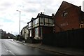
8
"The Victoria" public house, Hitchin
According to this http://www.aboutmyarea.co.uk/Hertfordshire/Hitchin/SG5/News/Reviews-and-Features/185482-A-History-of-The-Victoria-Public-House-Hitchin the building dates from 1865.
Image: © Jim Osley
Taken: 2 Nov 2014
0.21 miles
9

Top Field
The east stands and terraces at Top Field, home of Hitchin Town FC. Note the wooden stands/seats in this area - a feature replicated behind the south goal. The 'Please keep off the pitch' signs are always amusing as the fans shouldn't be there anyway and the players have to go there to warm up prior to the game! The pitch itself looks to be in fine fettle!
Top Field, Hitchin Town's home, is currently (2015) under threat from a supermarket development which would see the club relocated outside of town affecting its links with the local community.
Image: © Martin Addison
Taken: 27 Sep 2014
0.21 miles