IMAGES TAKEN NEAR TO
Bancroft, HITCHIN, SG5 1LA
Introduction
This page details the photographs taken nearby to Bancroft, SG5 1LA by members of the Geograph project.
The Geograph project started in 2005 with the aim of publishing, organising and preserving representative images for every square kilometre of Great Britain, Ireland and the Isle of Man.

There are currently over 7.5m images from over14,400 individuals and you can help contribute to the project by visiting https://www.geograph.org.uk
Image Map (Loading...)


Getting Data...Please wait
Leaflet Map data © OpenStreetMap
Images are licensed for reuse under creativecommons.org/licenses/by-sa/2.0
Notes
- Clicking on the map will re-center to the selected point.
- The higher the marker number, the further away the image location is from the centre of the postcode.
Image Listing (95 Images Found)
Images are licensed for reuse under creativecommons.org/licenses/by-sa/2.0
Image
Details
Distance
1
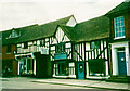
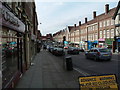
Timber-framed houses, now shops, Bancroft, Hitchin
These were built in the 17C.
Image: © Humphrey Bolton
Taken: 31 Mar 2001
0.02 miles
2
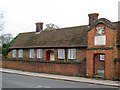
Skynner's Almshouses, Hitchin
Grade II listed 17th century almshouses.
Image: © Jim Osley
Taken: 2 Nov 2014
0.02 miles
3
Hitchin Library and Museum
Located in Paynes Park, the Library is on the left of the picture whilst the museum is on the right.
Image: © Samir Jeraj
Taken: 22 Mar 2006
0.03 miles
4
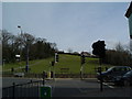
Windmill Hill
In the foreground is the junction connecting Queen Street, Hermitage Road and Walsworth Road. Windmill Hill leads up towards Hitchin Girls School and the Hibury area of Hitchin. Off to the left is edge of The Dell.
Image: © Samir Jeraj
Taken: 22 Mar 2006
0.03 miles
5
Hermitage Road
This is taken from the Queen Street end of Hermitage Rd. In the distance is Wilkinsons.
Image: © Samir Jeraj
Taken: 22 Mar 2006
0.03 miles
6
Hitchin History
This depicts the foundational history of Hitchin mentioning: King Offa, the River Hiz and the Hicce tribe. Now on the front of Hitchin Library, it was on the Sainsbury's on Brand Street until the supermarket relocated to the Bancroft Road area.
Image: © Samir Jeraj
Taken: 22 Mar 2006
0.03 miles
7
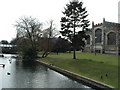
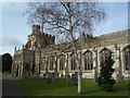
St Marys Church and river bank
People often lunch by the river along this bank, on the opposite side is a car park and a few market stalls. In the distance on the left of the picture is part of Hitchin Market.
Image: © Samir Jeraj
Taken: 22 Mar 2006
0.03 miles
8
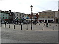
Old Market Square
Straight ahead is Bucklesbury. This is the site of special markets whereas the normal market takes place near to St. Marys Church and the Churchgate area.
Image: © Samir Jeraj
Taken: 22 Mar 2006
0.03 miles
9
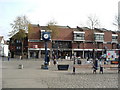
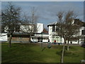
Churchgate Shopping Centre and Old Market Square
This whole area was earmarked for redevelopment. After much controversy and local opposition, the 'Churchgate' development is going to be limited to the 1960s buildings of the current Churchgate centre pictured.
Image: © Samir Jeraj
Taken: 22 Mar 2006
0.03 miles