IMAGES TAKEN NEAR TO
Riddy Hill Close, HITCHIN, SG4 9LE
Introduction
This page details the photographs taken nearby to Riddy Hill Close, SG4 9LE by members of the Geograph project.
The Geograph project started in 2005 with the aim of publishing, organising and preserving representative images for every square kilometre of Great Britain, Ireland and the Isle of Man.

There are currently over 7.5m images from over14,400 individuals and you can help contribute to the project by visiting https://www.geograph.org.uk
Image Map (Loading...)


Getting Data...Please wait
Leaflet Map data © OpenStreetMap
Images are licensed for reuse under creativecommons.org/licenses/by-sa/2.0
Notes
- Clicking on the map will re-center to the selected point.
- The higher the marker number, the further away the image location is from the centre of the postcode.
Image Listing (11 Images Found)
Images are licensed for reuse under creativecommons.org/licenses/by-sa/2.0
Image
Details
Distance
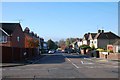
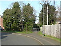
1
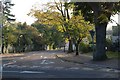
Wymondley Rd, Junction with Highbury Rd
Image: © Giovanni Gaidoni
Taken: 11 Oct 2008
0.10 miles
3
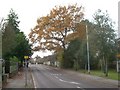
Wymondley Road, Hitchin
Oak tree in Autumn colours
Image: © Chris Wheatley
Taken: 25 Nov 2007
0.13 miles
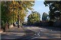
5
St John's Road - Top, Junction with Whitehill Road
Image: © Giovanni Gaidoni
Taken: 11 Oct 2008
0.19 miles
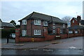
6
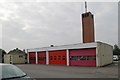
Hitchin fire station
Hitchin fire station, Newtons Way, Hitchin, Hertfordshire
Image: © Kevin Hale
Taken: 7 Oct 2007
0.20 miles
8

Sevensprings Way, Hitchin
The Cadent van lives here.
Image: © David Howard
Taken: 5 Dec 2022
0.22 miles
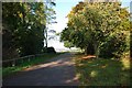
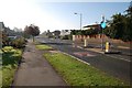
10
Footpath off Girons Close, Hitchin
Image: © Humphrey Bolton
Taken: 16 Feb 2016
0.24 miles