IMAGES TAKEN NEAR TO
Bradleys Corner, HITCHIN, SG4 0PR
Introduction
This page details the photographs taken nearby to Bradleys Corner, SG4 0PR by members of the Geograph project.
The Geograph project started in 2005 with the aim of publishing, organising and preserving representative images for every square kilometre of Great Britain, Ireland and the Isle of Man.

There are currently over 7.5m images from over14,400 individuals and you can help contribute to the project by visiting https://www.geograph.org.uk
Image Map (Loading...)


Getting Data...Please wait
Leaflet Map data © OpenStreetMap
Images are licensed for reuse under creativecommons.org/licenses/by-sa/2.0
Notes
- Clicking on the map will re-center to the selected point.
- The higher the marker number, the further away the image location is from the centre of the postcode.
Image Listing (13 Images Found)
Images are licensed for reuse under creativecommons.org/licenses/by-sa/2.0
Image
Details
Distance
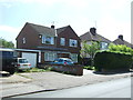
1
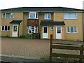
Development, Willian Road, Purwell
1 house becomes 3
Image: © Alex McGregor
Taken: 13 Jun 2011
0.07 miles
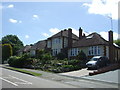
3
Kingswood Avenue, Purwell, Hitchin
Taken from opposite the end of Wilshere Crescent.
Image: © Humphrey Bolton
Taken: 31 Jan 2018
0.14 miles
4
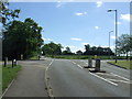
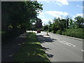
Willian Road
Looking east at the junction with Queenswood Drive.
Image: © JThomas
Taken: 10 Jun 2017
0.15 miles
5
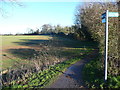
The Garden City Greenway at Queenswood Drive, Hitchin
Image: © Humphrey Bolton
Taken: 31 Jan 2018
0.16 miles

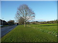
8
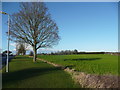
Verge and field alongside Kingswood Avenue, Purwell, Hitchin
This road forms the boundary of the built-up area of Hitchin.
Image: © Humphrey Bolton
Taken: 31 Jan 2018
0.18 miles