IMAGES TAKEN NEAR TO
Common Rise, HITCHIN, SG4 0HS
Introduction
This page details the photographs taken nearby to Common Rise, SG4 0HS by members of the Geograph project.
The Geograph project started in 2005 with the aim of publishing, organising and preserving representative images for every square kilometre of Great Britain, Ireland and the Isle of Man.

There are currently over 7.5m images from over14,400 individuals and you can help contribute to the project by visiting https://www.geograph.org.uk
Image Map
Images are licensed for reuse under creativecommons.org/licenses/by-sa/2.0
Notes
- Clicking on the map will re-center to the selected point.
- The higher the marker number, the further away the image location is from the centre of the postcode.
Image Listing (105 Images Found)
Images are licensed for reuse under creativecommons.org/licenses/by-sa/2.0
Image
Details
Distance
1
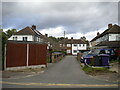
Narrow cul de sac off Common Rise, Hitchin
Giving access to houses numbered as part of Common Rise.
Image: © Richard Vince
Taken: 10 Oct 2020
0.02 miles
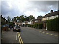
3
Footway, Meadow Bank, Hitchin
This is an old footpath that is shown running between allotment gardens on the 1881 1:2500 map.
Image: © Humphrey Bolton
Taken: 17 Feb 2015
0.06 miles
4
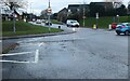
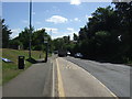
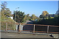
Roundabout on St Michael's Road, Hitchin
Image: © David Howard
Taken: 5 Dec 2022
0.09 miles
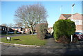
5
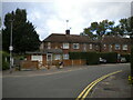
Houses on Common Rise, Hitchin
At its north end.
Image: © Richard Vince
Taken: 10 Oct 2020
0.09 miles