IMAGES TAKEN NEAR TO
Redoubt Close, HITCHIN, SG4 0FR
Introduction
This page details the photographs taken nearby to Redoubt Close, SG4 0FR by members of the Geograph project.
The Geograph project started in 2005 with the aim of publishing, organising and preserving representative images for every square kilometre of Great Britain, Ireland and the Isle of Man.

There are currently over 7.5m images from over14,400 individuals and you can help contribute to the project by visiting https://www.geograph.org.uk
Image Map (Loading...)


Getting Data...Please wait
Leaflet Map data © OpenStreetMap
Images are licensed for reuse under creativecommons.org/licenses/by-sa/2.0
Notes
- Clicking on the map will re-center to the selected point.
- The higher the marker number, the further away the image location is from the centre of the postcode.
Image Listing (43 Images Found)
Images are licensed for reuse under creativecommons.org/licenses/by-sa/2.0
Image
Details
Distance
1

Sidings by the curving railway line, Hitchin
Image: © Christopher Hilton
Taken: 5 Jul 2012
0.05 miles
2
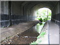
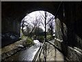
River Hiz in Walsworth
The Hiz rises to the south-west of Hitchin and flows in a generally north-easterly then a northerly direction to flow into the River Ivel. Here it passes through one of the arches of the East Coast Main Line railway Grove Road bridge, sharing the arch with a footpath.
Image: © Nigel Cox
Taken: 13 Jun 2010
0.05 miles
3

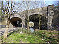
Strengthening boss on Grove Road rail bridge abutment
Image: © John Lucas
Taken: 27 Feb 2014
0.06 miles
4
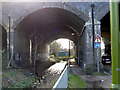
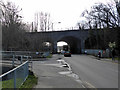
A view through the Grove Road rail Bridge, Hitchin
This view beneath the bridge shows three distinct stages in its development. The centre section is on the alignment of the original bridge which was opened to traffic in 1850 by the Great Northern Railway. An 1875 painting by Samuel Lucas shows that the bridge was constructed of wooden trestles supported by brick piers.
The furthest of the three sections is the bridge, opened in 1858, by which The Midland Railway (MR) originally gained access to the capital by means of a line from Bedford to Hitchin and thence with running powers over the Great Northern route to King's Cross. The direct MR route to St. Pancras was opened in 1868 and the Bedford-Hitchin line was then relegated to branch status. After closure of the Bedford line in 1964, the MR bridge became disused. It has, however, experienced a revival as it now forms part of the new Cambridge line flyover route, opened in 2013, built to avoid conflicting train movements on the East Coast Main Line.
The nearest section of the bridge was constructed in the 1890s when the southern end of the Great Northern route was widened to four tracks and the original centre section was presumably rebuilt to an all brick construction at the same time.
The river Hiz is seen flowing under the bridge. In the Lucas painting, mentioned above, the river is shown as being far wider, filling the whole arch width. It has now been relegated to virtual 'ditch' status in order to allow room for a pedestrian footway. The painting also presents a far more attractive scene than is evident today!
Image: © John Lucas
Taken: 27 Feb 2014
0.06 miles
6

Beneath the Grove Road rail bridge
See also Image for a description of the stages of the bridge's construction.
Image: © John Lucas
Taken: 27 Feb 2014
0.07 miles
7
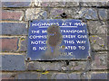
British Transport Commission sign on Grove Road bridge
Image: © John Lucas
Taken: 27 Feb 2014
0.07 miles
8
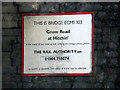
Grove Road rail bridge
The walkway beside the River Hiz.
Image: © John Lucas
Taken: 27 Feb 2014
0.07 miles
9
Grove Road rail bridge
The River Hiz arch.
Image: © John Lucas
Taken: 27 Feb 2014
0.08 miles
10
Grove Road rail bridge
For a history of the bridge, see Image
Image: © John Lucas
Taken: 27 Feb 2014
0.08 miles