IMAGES TAKEN NEAR TO
High Dane, HITCHIN, SG4 0BA
Introduction
This page details the photographs taken nearby to High Dane, SG4 0BA by members of the Geograph project.
The Geograph project started in 2005 with the aim of publishing, organising and preserving representative images for every square kilometre of Great Britain, Ireland and the Isle of Man.

There are currently over 7.5m images from over14,400 individuals and you can help contribute to the project by visiting https://www.geograph.org.uk
Image Map
Images are licensed for reuse under creativecommons.org/licenses/by-sa/2.0
Notes
- Clicking on the map will re-center to the selected point.
- The higher the marker number, the further away the image location is from the centre of the postcode.
Image Listing (26 Images Found)
Images are licensed for reuse under creativecommons.org/licenses/by-sa/2.0
Image
Details
Distance
1
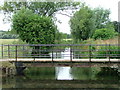
Bridge over River Purwell into Walsworth Common.
A busy place in the summer and at weekends. Ducks are fed, Water voles live in the banks of the river. This area is surrounded by housing but this spot is really rather nicer.
Image: © Robin Hall
Taken: 25 Jul 2005
0.06 miles
4
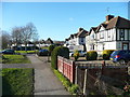
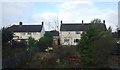
Mock-Tudor houses, Woolgrove Road, Walsworth
Image: © Humphrey Bolton
Taken: 17 Feb 2015
0.07 miles
5
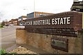
Hitchin Industrial Estate
This sign guards the entrance to the Hitchin Industrial Estate.
Image: © Ben Harris
Taken: 2 Apr 2011
0.09 miles
6
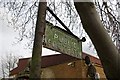
Footpath sign on Wilbury Way
This sign has clearly been here a while, since it names Hitchin Urban District Council, which was abolished no later than 1974.
Image: © Ben Harris
Taken: 2 Apr 2011
0.09 miles
7
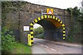
Woolgrove Road railway bridge
This bridge, number SBR-2, carries the Hitchin to Cambridge railway line over Woolgrove Road.
Image: © Ben Harris
Taken: 2 Apr 2011
0.10 miles
8
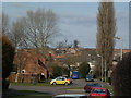
Walsworth Housing
In the foreground is Meadowbank - Walsworth Common is behind the first line of trees. The creamish partially obscured building in the centre is the Sailor Boy Public House. Out of the picture in the distance on the left is the rail line to Cambridge.
Image: © Samir Jeraj
Taken: 22 Mar 2006
0.12 miles
9
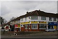
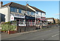
Shops on Grove Road
This small cluster of shops sits at the corner of Grove Road and Cadwell Lane. It includes a cafe, a convenience store, a barber, and a tattoo studio.
Image: © Ben Harris
Taken: 2 Apr 2011
0.13 miles