IMAGES TAKEN NEAR TO
North Lane, SANDY, SG19 3NT
Introduction
This page details the photographs taken nearby to North Lane, SG19 3NT by members of the Geograph project.
The Geograph project started in 2005 with the aim of publishing, organising and preserving representative images for every square kilometre of Great Britain, Ireland and the Isle of Man.

There are currently over 7.5m images from over14,400 individuals and you can help contribute to the project by visiting https://www.geograph.org.uk
Image Map
Images are licensed for reuse under creativecommons.org/licenses/by-sa/2.0
Notes
- Clicking on the map will re-center to the selected point.
- The higher the marker number, the further away the image location is from the centre of the postcode.
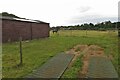
Image Listing (14 Images Found)
Images are licensed for reuse under creativecommons.org/licenses/by-sa/2.0
Image
Details
Distance
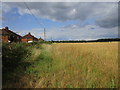
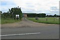
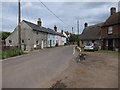
3
East Lane, Gamlingay Cinques
With a fallow field to the right.
Image: © Hugh Venables
Taken: 9 Jun 2012
0.09 miles
6
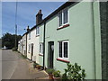
Colourful row of houses at Gamlingay Cinques
Image: © Peter S
Taken: 24 Jun 2018
0.13 miles
7
Five Coloured cottages at Gamlingay Cinques
Image: © Philip Jeffrey
Taken: 1 Oct 2023
0.13 miles
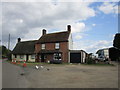
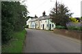
8
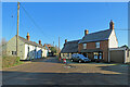
Houses at Gamlingay Cinques
A small settlement on the edge of Cambridgeshire, photographed on a cold and cloudless December morning.
Image: © John Sutton
Taken: 8 Dec 2022
0.14 miles
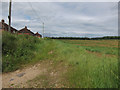
9
Gamlimgay Cinques
Hamlet near Gamlingay. See Image for details about the slightly unusual name.
Image: © Hugh Venables
Taken: 9 Jun 2012
0.15 miles