IMAGES TAKEN NEAR TO
Mill Street, SANDY, SG19 3JW
Introduction
This page details the photographs taken nearby to Mill Street, SG19 3JW by members of the Geograph project.
The Geograph project started in 2005 with the aim of publishing, organising and preserving representative images for every square kilometre of Great Britain, Ireland and the Isle of Man.

There are currently over 7.5m images from over14,400 individuals and you can help contribute to the project by visiting https://www.geograph.org.uk
Image Map
Images are licensed for reuse under creativecommons.org/licenses/by-sa/2.0
Notes
- Clicking on the map will re-center to the selected point.
- The higher the marker number, the further away the image location is from the centre of the postcode.
Image Listing (51 Images Found)
Images are licensed for reuse under creativecommons.org/licenses/by-sa/2.0
Image
Details
Distance
1

To St. Ives 14
Old milepost on the B1040 at Gamlingay, Cambridgeshire. For overall view see http://www.geograph.org.uk/photo/5525242.
Image: © Keith Evans
Taken: 29 Jun 2017
0.00 miles
2

Old Milepost
Old milepost on the B1040 at Gamlingay, Cambridgeshire. For close up view see http://www.geograph.org.uk/photo/5525245
Image: © Keith Evans
Taken: 29 Jun 2017
0.01 miles

4
Milestone, Gamlingay
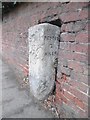
Carved stone post by the B1040, in parish of Gamlingay (South Cambridgeshire District), Mill Street, by No 32, on pavement, partially set into wall. Erected by the Shelton Lane, Bury & Stratton Turnpike Trust in the 19th century.
Inscription reads: // ST IVES / 14 / MILES // (G)AM(LINGAY) // POTTON / 2 / MILES //
Grade II listed by Historic England.
Milestone Society National ID: CA_SIPO14
Image: © Mike Faherty
Taken: 27 Nov 2017
0.03 miles
5
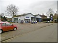
Gamlingay, garage
Worboy's Garage with petrol station, on Mill Street.
Image: © Mike Faherty
Taken: 27 Nov 2017
0.04 miles
6
Old Milestone by the B1040, Mill Street, Gamlingay
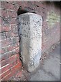
Carved stone post by the B1040, in parish of GAMLINGAY (SOUTH CAMBRIDGESHIRE District), Mill Street, by No 32, on pavement, partially set into wall, west side of road. Erected by the Shelton Lane, Bury & Stratton turnpike trust in the 19th century.
Inscription reads:-
: ST IVES / 14 / MILES. : : GAMLINGAY : : POTTON / 2 / MILES :
Grade II Listed. List Entry Number:1128190
https://historicengland.org.uk/listing/the-list/list-entry/1128190
Milestone Society National ID: CA_SIPO14.
Image: © Milestone Society
Taken: 27 Nov 2017
0.04 miles
8
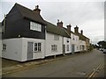
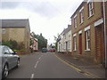
Gamlingay, cottages
An attractive diverse group on Mill Street.
Image: © Mike Faherty
Taken: 27 Nov 2017
0.05 miles
9

Ghost Sign
Ghost sign on building at Gamlingay, Cambridgeshire, For view of other sign see http://www.geograph.org.uk/photo/5525270 and overall view see http://www.geograph.org.uk/photo/5525293
Image: © Keith Evans
Taken: 29 Jun 2017
0.07 miles
10

Ghost Sign
Ghost sign on building at Gamlingay, Cambridgeshire, For view of other sign see http://www.geograph.org.uk/photo/5525258 and overall view see http://www.geograph.org.uk/photo/5525293
Image: © Keith Evans
Taken: 29 Jun 2017
0.07 miles