IMAGES TAKEN NEAR TO
Station Road, SANDY, SG19 3HB
Introduction
This page details the photographs taken nearby to Station Road, SG19 3HB by members of the Geograph project.
The Geograph project started in 2005 with the aim of publishing, organising and preserving representative images for every square kilometre of Great Britain, Ireland and the Isle of Man.

There are currently over 7.5m images from over14,400 individuals and you can help contribute to the project by visiting https://www.geograph.org.uk
Image Map
Images are licensed for reuse under creativecommons.org/licenses/by-sa/2.0
Notes
- Clicking on the map will re-center to the selected point.
- The higher the marker number, the further away the image location is from the centre of the postcode.
Image Listing (6 Images Found)
Images are licensed for reuse under creativecommons.org/licenses/by-sa/2.0
Image
Details
Distance
1

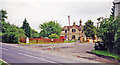
Gamlingay: former station hotel
The preserved lettering on the end gable reads "The Sultan Commercial Inn". The building stands on what from 1862 to 1968 was the approach road to Gamlingay Station, on the Bedford and Cambridge line. It is dated 1867. Like many country stations, Gamlingay was a good walk from the place it served.
Ben Brooksbanks' Image] shows the station building thirty years after closure. It is now a house and surrounded by newer ones. An industrial estate occupies the site of the former goods sidings.
Image: © John Sutton
Taken: 8 Dec 2022
0.00 miles
2
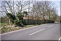
Former station at Gamlingay, 1998
View SE: the line was behind the surviving station house: ex-LNWR Bletchley - Bedford - Cambridge line, closed completely Bedford (to right) - Cambridge (to left) from 1/1/68, but eventual reopening is expected.
Image: © Ben Brooksbank
Taken: 16 Jun 1998
0.02 miles
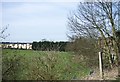
4

Varsity Line
The Varsity Line connected Oxford and Cambridge and train services ran on the section between Bedford and Cambridge until the end of 1967 https://en.wikipedia.org/wiki/Varsity_Line . Plans are underway to reopen the line in stages between Oxford and Cambridge, and the route is now known as East West Rail.
Some local authorities have taken steps to protect disused rail routes. Hence much of the original alignment between Oxford and Bedford will be/is being reused as it was because it was not built over in the meantime. However, there are several places between Bedford and Cambridge where the old route has been built over, and consequently a completely fresh route is likely to be constructed for this section.
This business facility has been built on the route of the old Varsity Line, close to the former Gamlingay Station http://www.disused-stations.org.uk/g/gamlingay/index.shtml . There are also some houses nearby which have been built on the alignment of the Varsity Line.
More details of future plans for East West Rail are available from https://www.eastwestrail.org.uk/central-section-overview/
Image: © Andrew Bodman
Taken: 10 Sep 2018
0.08 miles
6
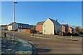
Gamlingay: Poppyfields
A new estate off Station Road, on the edge of the village, photographed just before 11 o'clock on a cloudless and frosty morning in early December.
Image: © John Sutton
Taken: 8 Dec 2022
0.19 miles