IMAGES TAKEN NEAR TO
Longstowe Road, SANDY, SG19 3EB
Introduction
This page details the photographs taken nearby to Longstowe Road, SG19 3EB by members of the Geograph project.
The Geograph project started in 2005 with the aim of publishing, organising and preserving representative images for every square kilometre of Great Britain, Ireland and the Isle of Man.

There are currently over 7.5m images from over14,400 individuals and you can help contribute to the project by visiting https://www.geograph.org.uk
Image Map
Images are licensed for reuse under creativecommons.org/licenses/by-sa/2.0
Notes
- Clicking on the map will re-center to the selected point.
- The higher the marker number, the further away the image location is from the centre of the postcode.
Image Listing (7 Images Found)
Images are licensed for reuse under creativecommons.org/licenses/by-sa/2.0
Image
Details
Distance
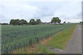
1
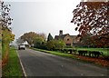
Gransden Lodge
A farm between the Gransdens and Longstowe (ahead), photographed on a misty autumn day.
Image: © John Sutton
Taken: 1 Nov 2015
0.01 miles
2
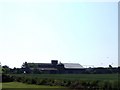
Farm buildings and rooks at Gransden Lodge
Image: © Jeff Tomlinson
Taken: 3 Jun 2007
0.03 miles
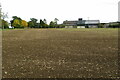
3
Gransden Lodge: farm buildings in the mist
Morning fog was slow to lift.
Image: © John Sutton
Taken: 1 Nov 2015
0.04 miles
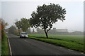
5
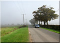
The B1046 near Gransden Lodge
The blue pick-up was slowing to turn in to the farm. The sun was struggling to burn off stubborn mist.
Image: © John Sutton
Taken: 1 Nov 2015
0.07 miles
7
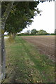
Tree lined bridleway out to the road
Image: © Philip Jeffrey
Taken: 24 Oct 2021
0.17 miles