IMAGES TAKEN NEAR TO
Gamlingay Road, SANDY, SG19 3DH
Introduction
This page details the photographs taken nearby to Gamlingay Road, SG19 3DH by members of the Geograph project.
The Geograph project started in 2005 with the aim of publishing, organising and preserving representative images for every square kilometre of Great Britain, Ireland and the Isle of Man.

There are currently over 7.5m images from over14,400 individuals and you can help contribute to the project by visiting https://www.geograph.org.uk
Image Map
Images are licensed for reuse under creativecommons.org/licenses/by-sa/2.0
Notes
- Clicking on the map will re-center to the selected point.
- The higher the marker number, the further away the image location is from the centre of the postcode.
Image Listing (6 Images Found)
Images are licensed for reuse under creativecommons.org/licenses/by-sa/2.0
Image
Details
Distance
3
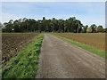
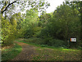
Entrance track for Gamlingay Wood
With parking near the entrance to the wood.
Image: © Hugh Venables
Taken: 7 Oct 2018
0.11 miles
6
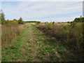
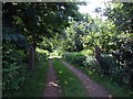
Track into Sugley Wood
A wildlife trust site where woodland is being allowed to naturally regenerate on what was an arable field until 2002.
Image: © Hugh Venables
Taken: 7 Oct 2018
0.21 miles