IMAGES TAKEN NEAR TO
Home Farm Close, SANDY, SG19 2TX
Introduction
This page details the photographs taken nearby to Home Farm Close, SG19 2TX by members of the Geograph project.
The Geograph project started in 2005 with the aim of publishing, organising and preserving representative images for every square kilometre of Great Britain, Ireland and the Isle of Man.

There are currently over 7.5m images from over14,400 individuals and you can help contribute to the project by visiting https://www.geograph.org.uk
Image Map
Images are licensed for reuse under creativecommons.org/licenses/by-sa/2.0
Notes
- Clicking on the map will re-center to the selected point.
- The higher the marker number, the further away the image location is from the centre of the postcode.
Image Listing (45 Images Found)
Images are licensed for reuse under creativecommons.org/licenses/by-sa/2.0
Image
Details
Distance
1
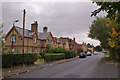
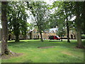
Tempsford Estate houses, Station Road
A number of houses of similar style were built in for workers on the Tempsford estate in the latter part of the 19th century. They are all dated, and have the Stuart crest and motto on the front. (See Image]). This row are dated 1874.
Image: © Richard Dorrell
Taken: 1 Nov 2013
0.04 miles
3
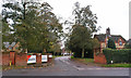
Entrance to Tempsford Hall
Tempsford village was cut in half by the realignment of the A1 trunk road in 1962. The entrance to the original Tempsford Hall is now in Church End, however, the original hall was destroyed by fire in 1898. This entrance, from Station Road, is to the new hall, built 1903, and now used as head office of the construction company Kier.
Image: © Richard Dorrell
Taken: 1 Nov 2013
0.04 miles
4
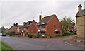
Modern houses in Tempsford
Tempsford village, and Station Road in particular, is lined by buildings of all styles and ages, from very recent to the 16th century. The red brick houses here are part of a small development of 4 and 5-bedroom detached houses which were built in the 1980s.
Image: © Richard Dorrell
Taken: 1 Nov 2013
0.04 miles
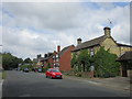
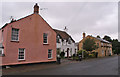
6
Houses in Tempsford
The white house is the former Black Horse pub which closed in 1967.
Image: © Jonathan Thacker
Taken: 12 Jul 2019
0.07 miles
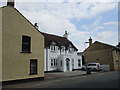
7
Former business premises, Station Road, Tempsford
There are no shops, pubs or school in Tempsford today, though this was not always the case. Here, and much altered, the pink building, built 1860s, was the village shop, which opened in 1905 and closed in 1989. The front garden area of white house is the site of The Black Horse pub dating back to 1837. The present house, built in 1933, was also The Black Horse pub, in which the last pint was pulled in 1967. The yellow brick cottages beyond were the home and premises of the village blacksmith, which was in business from the late 19th century into the 1960s.
Image: © Richard Dorrell
Taken: 1 Nov 2013
0.07 miles
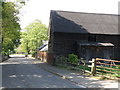
8
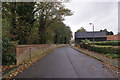
Western end of Station Road, Tempsford
Looking west past a barn at Stonebridge Farm towards the A1 junction. The wall on the left is on the boundary of the grounds of Tempsford Hall.
Image: © Richard Dorrell
Taken: 1 Nov 2013
0.07 miles
9
Stonebridge farm on Station road in Tempsford
Image: © Michael Trolove
Taken: 24 Apr 2009
0.08 miles
10
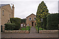
Tempsford Wesleyan Chapel, Station Road
Completed in 1804 with a Sunday School room added in 1878, this is the oldest Methodist Chapel in the St Neots area and is still in use with services every Sunday.
Image: © Richard Dorrell
Taken: 1 Nov 2013
0.09 miles