IMAGES TAKEN NEAR TO
Cuckoo Close, SANDY, SG19 2SR
Introduction
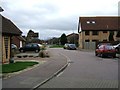
This page details the photographs taken nearby to Cuckoo Close, SG19 2SR by members of the Geograph project.
The Geograph project started in 2005 with the aim of publishing, organising and preserving representative images for every square kilometre of Great Britain, Ireland and the Isle of Man.

There are currently over 7.5m images from over14,400 individuals and you can help contribute to the project by visiting https://www.geograph.org.uk
Image Map
Images are licensed for reuse under creativecommons.org/licenses/by-sa/2.0
Notes
- Clicking on the map will re-center to the selected point.
- The higher the marker number, the further away the image location is from the centre of the postcode.
Image Listing (7 Images Found)
Images are licensed for reuse under creativecommons.org/licenses/by-sa/2.0
Image
Details
Distance
6
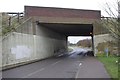
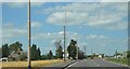
A1 underpass
Until 1967, this bridge carried the A1 over the Sandy to Bedford railway line, and Girtford Halt (http://www.disused-stations.org.uk/g/girtford_halt/index.shtml ) stood roughly where this picture was taken from. Now, the railway has been replaced by a minor road connecting two halves of a junction on the A1.
Image: © Ben Harris
Taken: 18 Feb 2012
0.25 miles