IMAGES TAKEN NEAR TO
Drove Road, SANDY, SG19 2HT
Introduction
This page details the photographs taken nearby to Drove Road, SG19 2HT by members of the Geograph project.
The Geograph project started in 2005 with the aim of publishing, organising and preserving representative images for every square kilometre of Great Britain, Ireland and the Isle of Man.

There are currently over 7.5m images from over14,400 individuals and you can help contribute to the project by visiting https://www.geograph.org.uk
Image Map
Images are licensed for reuse under creativecommons.org/licenses/by-sa/2.0
Notes
- Clicking on the map will re-center to the selected point.
- The higher the marker number, the further away the image location is from the centre of the postcode.
Image Listing (7 Images Found)
Images are licensed for reuse under creativecommons.org/licenses/by-sa/2.0
Image
Details
Distance
1
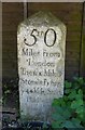
Old Milestone by the unclassified Drove Road, near Gamlingay
Carved stone post by the UC road, in parish of Gamlingay (South Cambridgeshire District), Drove Road, outside Park Farm, hidden between fence and holly hedge, on East side of road. Drove Road stone, erected by a private estate in the 18th century.
Inscription reads:-
50
Miles from
London
The six Miles
Stone from
ye 44 Mile Stone
in Baldock Lane
To this Place
was set up By
Rog, Burgoyne Bart
in 1751.
Grade II listed.
List Entry Number: 1163723 https://historicengland.org.uk/listing/the-list/list-entry/1163723
Milestone Society National ID: CA_LY50a
Image: © MW Hallett
Taken: 8 Feb 2003
0.08 miles
3
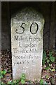
50 Miles From London
Old milepost near to Everton, Cambridgeshire. For overall view see http://www.geograph.org.uk/photo/5525442
Image: © Keith Evans
Taken: 29 Jun 2017
0.08 miles
4
Old Milepost
Old milepost near to Everton, Cambridgeshire. For close up view see http://www.geograph.org.uk/photo/5525445
Image: © Keith Evans
Taken: 29 Jun 2017
0.10 miles
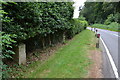
5
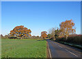
Oak and silver birch leaves in December
Drove Road, near Gamlingay, on a cloudless morning in early December. Bedfordshire is to the left of the road, which marks the boundary with Cambridgeshire.
Image: © John Sutton
Taken: 8 Dec 2022
0.13 miles
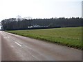
6
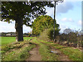
Farm track running west from Drove Road
Image: © Robin Webster
Taken: 5 Nov 2017
0.14 miles
7
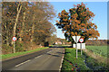
Gamlingay Heath: Drove Road
Looking towards Park Farm on a bright December morning. The edge of White Wood is on the left.
Image: © John Sutton
Taken: 8 Dec 2022
0.21 miles