IMAGES TAKEN NEAR TO
Butchers Lane, SANDY, SG19 2EX
Introduction
This page details the photographs taken nearby to Butchers Lane, SG19 2EX by members of the Geograph project.
The Geograph project started in 2005 with the aim of publishing, organising and preserving representative images for every square kilometre of Great Britain, Ireland and the Isle of Man.

There are currently over 7.5m images from over14,400 individuals and you can help contribute to the project by visiting https://www.geograph.org.uk
Image Map
Images are licensed for reuse under creativecommons.org/licenses/by-sa/2.0
Notes
- Clicking on the map will re-center to the selected point.
- The higher the marker number, the further away the image location is from the centre of the postcode.
Image Listing (46 Images Found)
Images are licensed for reuse under creativecommons.org/licenses/by-sa/2.0
Image
Details
Distance
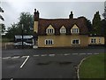
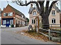
1
Wrestlingworth, centre of village
Taken at the junction of High Street (left) and Butchers Lane (right).
Image: © David Kemp
Taken: 8 Mar 2014
0.03 miles
3
Butchers Lane at the junction of High Street Wrestlingworth
Image: © David Howard
Taken: 24 Oct 2021
0.06 miles
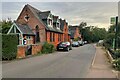
4
House dated 1829 in Church Lane, Wrestlingworth
The date is between the windows on the first floor. See http://www.britishlistedbuildings.co.uk/en-38483-3-church-lane-wrestlingworth-and-cockayne for entry in British Listed Buildings
Image: © Bikeboy
Taken: 22 Dec 2014
0.06 miles
5
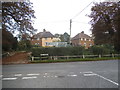
Potton Road at the junction of High Street, Wrestlingworth
Image: © David Howard
Taken: 28 Sep 2017
0.07 miles
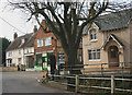
6
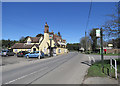
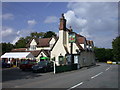
Wrestlingworth High Street and The Chequers
The Chequers is Grade II listed and dates from the late 17th or early 18th century.
Image: © John Sutton
Taken: 5 Apr 2018
0.10 miles
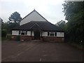
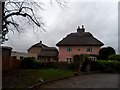
7

Bungalow on High Street, Wrestlingworth
Image: © David Howard
Taken: 28 Sep 2017
0.10 miles
8
The Chequers PH, Wrestlingworth
Late C17 or early C18. Colourwashed roughcast render, apparently encasing some timber framing. Clay tile roof of fairly steep pitch. LH gable end has projecting brick chimney stack. Grade II listed. http://www.heritagegateway.org.uk/Gateway/Results_Single.aspx?resourceID=5&uid=38497
Image: © Keith Edkins
Taken: 13 Sep 2007
0.11 miles