IMAGES TAKEN NEAR TO
Sand Lane, SANDY, SG19 2DQ
Introduction
This page details the photographs taken nearby to Sand Lane, SG19 2DQ by members of the Geograph project.
The Geograph project started in 2005 with the aim of publishing, organising and preserving representative images for every square kilometre of Great Britain, Ireland and the Isle of Man.

There are currently over 7.5m images from over14,400 individuals and you can help contribute to the project by visiting https://www.geograph.org.uk
Image Map
Images are licensed for reuse under creativecommons.org/licenses/by-sa/2.0
Notes
- Clicking on the map will re-center to the selected point.
- The higher the marker number, the further away the image location is from the centre of the postcode.
Image Listing (10 Images Found)
Images are licensed for reuse under creativecommons.org/licenses/by-sa/2.0
Image
Details
Distance

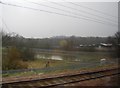
3
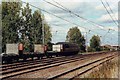
Freight train north of Sandy
The EW&S loco heads north with empty wagons.
Image: © nick macneill
Taken: 12 Sep 2003
0.07 miles

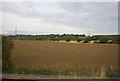
5
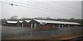
View from a Peterborough-London train - industrial units at Sandy
Image: © Nigel Thompson
Taken: 7 Feb 2017
0.13 miles
8

Sandy: view up the hill towards pylon line and TV transmitter
Image: © Christopher Hilton
Taken: 12 Jul 2015
0.20 miles
9
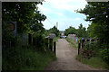
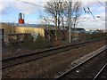
Railway bridge between Sand Lane and Cambridge Road
Image: © Robert Eva
Taken: 8 Jun 2018
0.21 miles