IMAGES TAKEN NEAR TO
Chapel Court, SANDY, SG19 2BX
Introduction
This page details the photographs taken nearby to Chapel Court, SG19 2BX by members of the Geograph project.
The Geograph project started in 2005 with the aim of publishing, organising and preserving representative images for every square kilometre of Great Britain, Ireland and the Isle of Man.

There are currently over 7.5m images from over14,400 individuals and you can help contribute to the project by visiting https://www.geograph.org.uk
Image Map
Images are licensed for reuse under creativecommons.org/licenses/by-sa/2.0
Notes
- Clicking on the map will re-center to the selected point.
- The higher the marker number, the further away the image location is from the centre of the postcode.
Image Listing (84 Images Found)
Images are licensed for reuse under creativecommons.org/licenses/by-sa/2.0
Image
Details
Distance
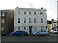
1
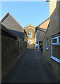
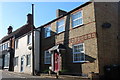
Potton: towards the former Congregational Church
The church, behind Sun Street, opened in 1848, was renovated in 1899 and closed in 1987. The chapel and the wall on the left are made from yellow brick and the local ironstone. These thin stones, sometimes laid in herringbone pattern, are known as slips.
Image: © John Sutton
Taken: 7 Jan 2018
0.01 miles
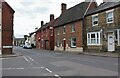
3
Potton: Sun Street
The timbered Sun House (formerly The Sun Inn), on the left, is one of the few wooden houses in the centre of Potton which survived the Great Fire of 1783.
Image: © John Sutton
Taken: 7 Jan 2018
0.04 miles
4
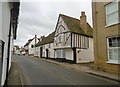
Potton, Sun House
C16 half-timbered house on Sun Street, once Sun Inn; listed by Historic England, Grade II: http://www.imagesofengland.org.uk/Details/Default.aspx?id=38433&mode=adv
Image: © Mike Faherty
Taken: 27 Nov 2017
0.04 miles
6
Royal Fisheries, Potton
The building dates from the seventeenth century https://historicengland.org.uk/listing/the-list/list-entry/1312055?section=official-list-entry
Much of Potton was destroyed by fire in 1783 but this building survived.
Image: © Jonathan Thacker
Taken: 30 Apr 2022
0.05 miles
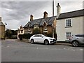
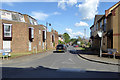
7
Station Road, Potton
At the corner of Chapel Street
Image: © David Howard
Taken: 29 Aug 2021
0.05 miles
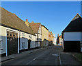
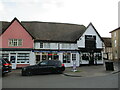
8
B1042 Royston Street, Potton
Fairly new development to either side at the corner. What was here before?
Image: © Robin Webster
Taken: 14 May 2017
0.05 miles
9
Lion Court, Potton
Dates from the eighteenth century but contains earlier remains https://historicengland.org.uk/listing/the-list/list-entry/1114076?section=official-list-entry
Image: © Jonathan Thacker
Taken: 30 Apr 2022
0.05 miles
10
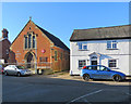
Potton Salvation Army Citadel
The former Methodist Church on Chapel Street has been a Salvation Army Citadel since 1976. The picture was taken from the end of Bull Street. Horslow Street is to the right.
Image: © John Sutton
Taken: 7 Jan 2018
0.06 miles