IMAGES TAKEN NEAR TO
Tempsford Road, SANDY, SG19 2AL
Introduction
This page details the photographs taken nearby to Tempsford Road, SG19 2AL by members of the Geograph project.
The Geograph project started in 2005 with the aim of publishing, organising and preserving representative images for every square kilometre of Great Britain, Ireland and the Isle of Man.

There are currently over 7.5m images from over14,400 individuals and you can help contribute to the project by visiting https://www.geograph.org.uk
Image Map
Images are licensed for reuse under creativecommons.org/licenses/by-sa/2.0
Notes
- Clicking on the map will re-center to the selected point.
- The higher the marker number, the further away the image location is from the centre of the postcode.
Image Listing (21 Images Found)
Images are licensed for reuse under creativecommons.org/licenses/by-sa/2.0
Image
Details
Distance
1
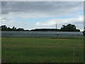
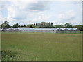
Greenhouses by Tempsford Road, Blunham
Image: © David Howard
Taken: 19 Feb 2023
0.03 miles
3
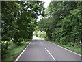
Tempsford Road
Heading north east from Blunham.
Image: © JThomas
Taken: 15 Aug 2015
0.08 miles
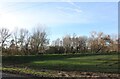
5
Glasshouses, near Church End, Tempsford
Image: © Simon Mortimer
Taken: 29 May 2007
0.09 miles
6
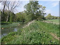
Kingfisher Way on the Ivel
A long distance walking path by the Ivel.
http://www.ldwa.org.uk/ldp/members/show_path.php?path_name=Kingfisher+Way
Image: © Michael Trolove
Taken: 24 Apr 2009
0.12 miles
8
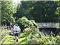
Bedfordshire Walking Festival
Walkers taking part in the Bedfordshire Walking Festival approachint a bridge over the River Ivel, just outside Blunham
Image: © Dennis simpson
Taken: 12 Sep 2009
0.12 miles
9
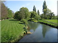
The view from Blunham bridge of the upstream River Ivel
Image: © Michael Trolove
Taken: 24 Apr 2009
0.15 miles
10
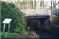
Blunham Navigation Bridge
This bridge was built in the early 19th century when a bypass channel was dug to make the River Ivel navigable past Blunham mill. I learnt this from the interpretation board standing next to it.
Image: © Ben Harris
Taken: 18 Feb 2012
0.15 miles