IMAGES TAKEN NEAR TO
Wynnefield Walk, SANDY, SG19 1QS
Introduction
This page details the photographs taken nearby to Wynnefield Walk, SG19 1QS by members of the Geograph project.
The Geograph project started in 2005 with the aim of publishing, organising and preserving representative images for every square kilometre of Great Britain, Ireland and the Isle of Man.

There are currently over 7.5m images from over14,400 individuals and you can help contribute to the project by visiting https://www.geograph.org.uk
Image Map
Images are licensed for reuse under creativecommons.org/licenses/by-sa/2.0
Notes
- Clicking on the map will re-center to the selected point.
- The higher the marker number, the further away the image location is from the centre of the postcode.
Image Listing (18 Images Found)
Images are licensed for reuse under creativecommons.org/licenses/by-sa/2.0
Image
Details
Distance
2
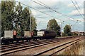
Freight train north of Sandy
The EW&S loco heads north with empty wagons.
Image: © nick macneill
Taken: 12 Sep 2003
0.14 miles
3
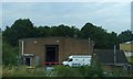
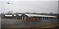
View from a Peterborough-London train - industrial units at Sandy
Image: © Nigel Thompson
Taken: 7 Feb 2017
0.16 miles
6
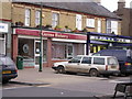
Gunns bakery
Gunn's Bakery is in Sandy Town Centre, it is opposite Stead and Simpsons the shoe shop.
This picture was taken on a geography field trip discovering land use with St Swithun's V.C. Lower School.
The land use is mainly business.
Image: © St Swithun's VC Lower School
Taken: 15 Mar 2007
0.20 miles
7
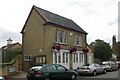
Sandy old fire station
Sandy old fire station, Cambridge Road, Sandy, Bedfordshire is now used by the Town Council
Image: © Kevin Hale
Taken: 30 Jun 2010
0.23 miles
8
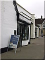
Allders opticians
Allders the opticians is on the market square.
This picture was taken on a geography field trip discovering land use with St Swithun's V.C. Lower School.
The land use around this area is mostly business and some housing.
Image: © St Swithun's VC Lower School
Taken: 15 Mar 2007
0.23 miles
9
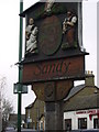
The Sandy Sign
This picture was taken on a geography field trip discovering land use with St Swithun's V.C. Lower School.
I took this picture near the shoe shop.
The land use was mostly business with a little bit of housing.
Image: © St Swithun's VC Lower School
Taken: 15 Mar 2007
0.23 miles
10
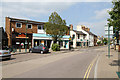
Cambridge Road
Seen from Market Square
Image: © Martin Addison
Taken: 2 Jun 2011
0.24 miles