IMAGES TAKEN NEAR TO
Edward Close, SANDY, SG19 1JT
Introduction
This page details the photographs taken nearby to Edward Close, SG19 1JT by members of the Geograph project.
The Geograph project started in 2005 with the aim of publishing, organising and preserving representative images for every square kilometre of Great Britain, Ireland and the Isle of Man.

There are currently over 7.5m images from over14,400 individuals and you can help contribute to the project by visiting https://www.geograph.org.uk
Image Map
Images are licensed for reuse under creativecommons.org/licenses/by-sa/2.0
Notes
- Clicking on the map will re-center to the selected point.
- The higher the marker number, the further away the image location is from the centre of the postcode.
Image Listing (62 Images Found)
Images are licensed for reuse under creativecommons.org/licenses/by-sa/2.0
Image
Details
Distance
1
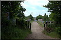
Railway bridge between Sand Lane and Cambridge Road
Image: © Robert Eva
Taken: 8 Jun 2018
0.08 miles
2
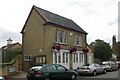
Sandy old fire station
Sandy old fire station, Cambridge Road, Sandy, Bedfordshire is now used by the Town Council
Image: © Kevin Hale
Taken: 30 Jun 2010
0.12 miles
4
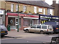
Gunns bakery
Gunn's Bakery is in Sandy Town Centre, it is opposite Stead and Simpsons the shoe shop.
This picture was taken on a geography field trip discovering land use with St Swithun's V.C. Lower School.
The land use is mainly business.
Image: © St Swithun's VC Lower School
Taken: 15 Mar 2007
0.14 miles
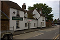
5
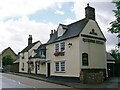
The Queens Head Public House, Cambridge Road, Sandy
Image: © N Avery
Taken: 17 Jul 2007
0.15 miles
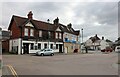
6
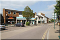
Cambridge Road
Seen from Market Square
Image: © Martin Addison
Taken: 2 Jun 2011
0.15 miles
7
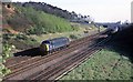
Passing trains
Before the main East Coast route was wired north of Hitchin the line was very open. A light locomotive for Kings Cross is passing the 1630 hrs Kings Cross to Peterborough service just north of Sandy station hauled by 47210.
Image: © roger geach
Taken: 15 Apr 1981
0.15 miles
8
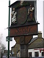
The Sandy Sign
This picture was taken on a geography field trip discovering land use with St Swithun's V.C. Lower School.
I took this picture near the shoe shop.
The land use was mostly business with a little bit of housing.
Image: © St Swithun's VC Lower School
Taken: 15 Mar 2007
0.16 miles
10
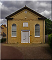
Sandy : Afnan Library
The Afnan Library (https://www.afnanlibrary.org/about/) is housed in a former non-Conformist chapel.
Image: © Jim Osley
Taken: 6 Jul 2022
0.17 miles