IMAGES TAKEN NEAR TO
Lime Avenue, SANDY, SG19 1GA
Introduction
This page details the photographs taken nearby to Lime Avenue, SG19 1GA by members of the Geograph project.
The Geograph project started in 2005 with the aim of publishing, organising and preserving representative images for every square kilometre of Great Britain, Ireland and the Isle of Man.

There are currently over 7.5m images from over14,400 individuals and you can help contribute to the project by visiting https://www.geograph.org.uk
Image Map
Images are licensed for reuse under creativecommons.org/licenses/by-sa/2.0
Notes
- Clicking on the map will re-center to the selected point.
- The higher the marker number, the further away the image location is from the centre of the postcode.
Image Listing (14 Images Found)
Images are licensed for reuse under creativecommons.org/licenses/by-sa/2.0
Image
Details
Distance

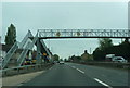
2
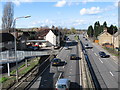
A1 looking north from footbridge
The A1 road looking north from the Beeston footbridge, which forms part of the Greensands ridge walk.
Image: © Robert Lacey
Taken: 3 Mar 2007
0.13 miles
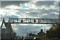
4
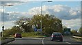
A1 southbound, Beeston
From the road at least Beeston looks like a place hammered into submission by the passing traffic; an upgrade of the A1 to full motorway status would presumably involve bypassing the village, and bringing peace to those houses right on the road for the first time in generations.
Image: © Christopher Hilton
Taken: 20 Feb 2012
0.15 miles
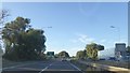
5
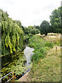
Sandy : River Ivel
https://langfordhistorysociety.org.uk/the-river-ivel/
Image: © Jim Osley
Taken: 6 Jul 2022
0.15 miles
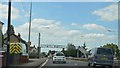
10
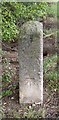
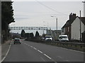
Old Milestone by the A1, A428 slip road
Carved stone post by the A1, in parish of SANDY (MID BEDFORDSHIRE District), Beeston, by slip road onto A428, set into verge, on West side of road. Erected by the Biggleswade to Alconbury Hill turnpike trust in the 18th century.
Inscription reads:-
48
MILES
FROM
LONDON
BEESTON
Carved benchmark on lower face.
Milestone Society National ID: BD_LY48.
Image: © M Knight
Taken: 1 Nov 2002
0.18 miles