IMAGES TAKEN NEAR TO
Church Path, SANDY, SG19 1ET
Introduction
This page details the photographs taken nearby to Church Path, SG19 1ET by members of the Geograph project.
The Geograph project started in 2005 with the aim of publishing, organising and preserving representative images for every square kilometre of Great Britain, Ireland and the Isle of Man.

There are currently over 7.5m images from over14,400 individuals and you can help contribute to the project by visiting https://www.geograph.org.uk
Image Map
Images are licensed for reuse under creativecommons.org/licenses/by-sa/2.0
Notes
- Clicking on the map will re-center to the selected point.
- The higher the marker number, the further away the image location is from the centre of the postcode.
Image Listing (20 Images Found)
Images are licensed for reuse under creativecommons.org/licenses/by-sa/2.0
Image
Details
Distance
1
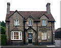
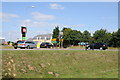
Rose and Crown
The Rose and Crown at Girtford, just off the A1 near Sandy.
Image: © Peter McDermott
Taken: 27 Jun 2009
0.03 miles
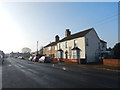
2
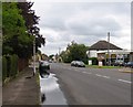
London Road
London Road was the A1 until a few years ago. The traffic still thunders by to the rear of the properties to the right.
Image: © Andrew Tatlow
Taken: 26 May 2006
0.10 miles
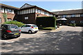
5
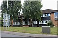
Allison House on Bedford Road, Sandy
This is a very smart looking care home.
Image: © David Howard
Taken: 29 Aug 2021
0.11 miles
7
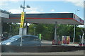
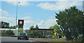
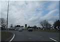
Roundabout at the junction of the A1 and A603
Image: © Philip Halling
Taken: 31 Aug 2013
0.11 miles
10
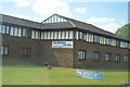
Holiday Inn, Sandy
The Holiday Inn at Sandy in Bedfordshire is near the junction of the A1 with the A603.
Image: © Philip Halling
Taken: 31 Aug 2013
0.17 miles