IMAGES TAKEN NEAR TO
Woolfield, SANDY, SG19 1AR
Introduction
This page details the photographs taken nearby to Woolfield, SG19 1AR by members of the Geograph project.
The Geograph project started in 2005 with the aim of publishing, organising and preserving representative images for every square kilometre of Great Britain, Ireland and the Isle of Man.

There are currently over 7.5m images from over14,400 individuals and you can help contribute to the project by visiting https://www.geograph.org.uk
Image Map
Images are licensed for reuse under creativecommons.org/licenses/by-sa/2.0
Notes
- Clicking on the map will re-center to the selected point.
- The higher the marker number, the further away the image location is from the centre of the postcode.
Image Listing (46 Images Found)
Images are licensed for reuse under creativecommons.org/licenses/by-sa/2.0
Image
Details
Distance
3
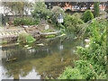
River Ivel, Sandy
One of the channels of the River Ivel can be seen here flowing around the backs of houses at Sandy. The Ivel is predominantly a Bedfordshire river and a tributary of the Great Ouse.
Image: © Stephen McKay
Taken: 23 Aug 2023
0.08 miles
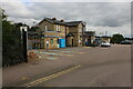
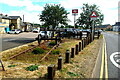
4
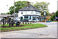
The Bell and a railway relic, Sandy station
The railway relic looks like a carriage axle.
Image: © Robert Eva
Taken: 8 Jun 2018
0.08 miles
6
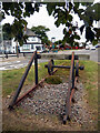
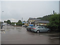
The Railway Triangle, Sandy
According to an accompanying information board, this somewhat curious display constitutes the Railway Triangle, a 'gateway garden for Sandy'. It goes on to say that the Sandy Enhancement Group have created a number of gardens for the public to enjoy. When the opportunity arose to create a new garden at the entrance to Sandy railway station a railway theme seemed most appropriate. Whether a short length of rusty track with buffer stops and a couple of old wheels set on a patch of scruffy grass really constitutes a garden is a moot point. However, here it is and it at least makes for a talking point. In the background is the Bell public house.
Image: © Stephen McKay
Taken: 23 Aug 2023
0.08 miles
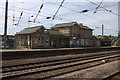
7
The Railway Triangle
Railway relics form the centrepiece of this display in Station Road, created in 2011 by the Sandy Enhancement Group with assistance from local councils, organisations and volunteers. In the background can be seen the station buildings designed in 1850 by Henry Goddard for the Great Northern Railway. Pevsner and Charles O'Brien describe these as "typically economical, yellow brick with round-arched windows."
Stefan Czapski has drawn my attention to the very similar design of the Image at Algarkirk & Sutterton, well maintained in private ownership although the station saw no passengers after 1961 and the line closed completely completely in 1964, the alignment later being adopted by the A16 road. Sadly both stations have lost their original bargeboards.
For a view from the other direction see Stephen McKay's Image
Image: © Tiger
Taken: 23 Aug 2022
0.08 miles