IMAGES TAKEN NEAR TO
London Road, BIGGLESWADE, SG18 9TD
Introduction
This page details the photographs taken nearby to London Road, SG18 9TD by members of the Geograph project.
The Geograph project started in 2005 with the aim of publishing, organising and preserving representative images for every square kilometre of Great Britain, Ireland and the Isle of Man.

There are currently over 7.5m images from over14,400 individuals and you can help contribute to the project by visiting https://www.geograph.org.uk
Image Map
Images are licensed for reuse under creativecommons.org/licenses/by-sa/2.0
Notes
- Clicking on the map will re-center to the selected point.
- The higher the marker number, the further away the image location is from the centre of the postcode.
Image Listing (3 Images Found)
Images are licensed for reuse under creativecommons.org/licenses/by-sa/2.0
Image
Details
Distance
1
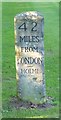
Old Milestone by the A1, south of Biggleswade
Carved stone post by the A1, in parish of BIGGLESWADE (MID BEDFORDSHIRE District), London Road, Edworth, Bleak Hall, on grass verge by entrance, North-bound carriageway, on West side of road. Erected by the Stevenage & Biggleswade turnpike trust in the 19th century.
Inscription reads:-
: 42 / MILES / FROM / LONDON / --- / HOLME : : 42 / MILES / TO / LONDON :
Milestone Society National ID: BD_LY42
Image: © M Knight
Taken: 1 Nov 2002
0.12 miles
3
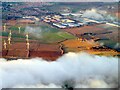
Biggleswade Windfarm and Stratton Business Park
An aerial view from near Henlow. Three of the ten turbines are obscured by cloud Image Also known as Langford and Biggleswade Wind Farm, but just Biggleswade Wind Farm on the OS map.
Image: © M J Richardson
Taken: 23 Dec 2023
0.21 miles