IMAGES TAKEN NEAR TO
Mager Way, BIGGLESWADE, SG18 9PW
Introduction
This page details the photographs taken nearby to Mager Way, SG18 9PW by members of the Geograph project.
The Geograph project started in 2005 with the aim of publishing, organising and preserving representative images for every square kilometre of Great Britain, Ireland and the Isle of Man.

There are currently over 7.5m images from over14,400 individuals and you can help contribute to the project by visiting https://www.geograph.org.uk
Image Map
Images are licensed for reuse under creativecommons.org/licenses/by-sa/2.0
Notes
- Clicking on the map will re-center to the selected point.
- The higher the marker number, the further away the image location is from the centre of the postcode.
Image Listing (12 Images Found)
Images are licensed for reuse under creativecommons.org/licenses/by-sa/2.0
Image
Details
Distance
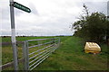
1
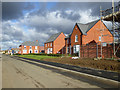
New housing, Langford
On former agricultural land.
Image: © Robin Webster
Taken: 12 Nov 2017
0.06 miles
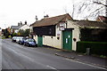
2
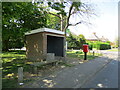
Bus shelter and post box, Station Road, Langford
Image: © Jonathan Thacker
Taken: 30 Apr 2022
0.17 miles
4
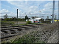
Electrified Main Line
View across the East Coast Line towards Langford.
Image: © Jonathan Billinger
Taken: 15 Apr 2008
0.21 miles
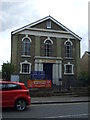
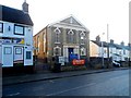
6
Langford Post Office and Store
On High Street.
Image: © JThomas
Taken: 15 Aug 2015
0.21 miles
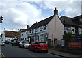
8
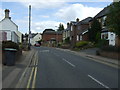
High Street, Langford (B659)
Looking north.
Image: © JThomas
Taken: 15 Aug 2015
0.21 miles
9

Wheat field near Langford
The roofs of recent housing in the south-eastern part of the village can be seen beyond the railway.
Image: © Jonathan Thacker
Taken: 30 Apr 2022
0.22 miles