IMAGES TAKEN NEAR TO
Manor Close, BIGGLESWADE, SG18 9PU
Introduction
This page details the photographs taken nearby to Manor Close, SG18 9PU by members of the Geograph project.
The Geograph project started in 2005 with the aim of publishing, organising and preserving representative images for every square kilometre of Great Britain, Ireland and the Isle of Man.

There are currently over 7.5m images from over14,400 individuals and you can help contribute to the project by visiting https://www.geograph.org.uk
Image Map
Images are licensed for reuse under creativecommons.org/licenses/by-sa/2.0
Notes
- Clicking on the map will re-center to the selected point.
- The higher the marker number, the further away the image location is from the centre of the postcode.
Image Listing (11 Images Found)
Images are licensed for reuse under creativecommons.org/licenses/by-sa/2.0
Image
Details
Distance
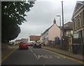
1
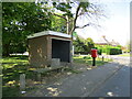
Bus shelter and post box, Station Road, Langford
Image: © Jonathan Thacker
Taken: 30 Apr 2022
0.06 miles
2
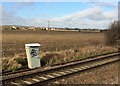
View from a Peterborough-London train - Graffiti in the countryside
Image: © Nigel Thompson
Taken: 7 Feb 2017
0.15 miles
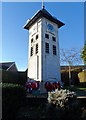
5
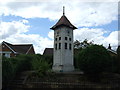
Clock Tower War Memorial, Langford
On High Street.
Image: © JThomas
Taken: 15 Aug 2015
0.18 miles
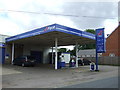
6
Langford Post Office and Store
On High Street.
Image: © JThomas
Taken: 15 Aug 2015
0.20 miles
7
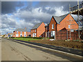
New housing, Langford
On former agricultural land.
Image: © Robin Webster
Taken: 12 Nov 2017
0.20 miles
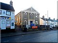
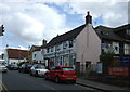
10
High Street, Langford
By the church and post office
Image: © David Howard
Taken: 31 May 2012
0.22 miles