IMAGES TAKEN NEAR TO
Stanford Road, BIGGLESWADE, SG18 9HX
Introduction
This page details the photographs taken nearby to Stanford Road, SG18 9HX by members of the Geograph project.
The Geograph project started in 2005 with the aim of publishing, organising and preserving representative images for every square kilometre of Great Britain, Ireland and the Isle of Man.

There are currently over 7.5m images from over14,400 individuals and you can help contribute to the project by visiting https://www.geograph.org.uk
Image Map
Images are licensed for reuse under creativecommons.org/licenses/by-sa/2.0
Notes
- Clicking on the map will re-center to the selected point.
- The higher the marker number, the further away the image location is from the centre of the postcode.
Image Listing (16 Images Found)
Images are licensed for reuse under creativecommons.org/licenses/by-sa/2.0
Image
Details
Distance
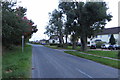
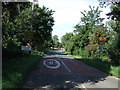
7
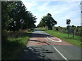
Leaving Southill
Heading south east on Stanford Road.
Image: © JThomas
Taken: 22 Aug 2015
0.12 miles
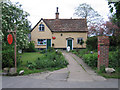
8
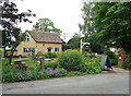
Vintage Tearoom, Southill
This is an estate house, dated S.W.1815. The listing details state that it is timber framed and might have been altered from an earlier building. One room was used as a village shop, and it is shown as a post office on the 1972 1:2500 map. The letter box has GR for George V.
Image: © Humphrey Bolton
Taken: 23 Jun 2019
0.13 miles
10
Post office and stores, Southill, Beds
situated in the High Street.
Image: © Rodney Burton
Taken: 19 May 2006
0.14 miles