IMAGES TAKEN NEAR TO
Old Warden, BIGGLESWADE, SG18 9HG
Introduction
This page details the photographs taken nearby to SG18 9HG by members of the Geograph project.
The Geograph project started in 2005 with the aim of publishing, organising and preserving representative images for every square kilometre of Great Britain, Ireland and the Isle of Man.

There are currently over 7.5m images from over14,400 individuals and you can help contribute to the project by visiting https://www.geograph.org.uk
Image Map
Images are licensed for reuse under creativecommons.org/licenses/by-sa/2.0
Notes
- Clicking on the map will re-center to the selected point.
- The higher the marker number, the further away the image location is from the centre of the postcode.
Image Listing (4 Images Found)
Images are licensed for reuse under creativecommons.org/licenses/by-sa/2.0
Image
Details
Distance
1
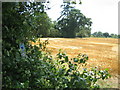
Sweetbrier Farm from Greensand Ridge Walk footpath
Field has just been 'Combined'; footpath is also Old Warden circular footpath; farmhouse just visible between trees beyond the field.
Image: © ian saunders
Taken: 4 Aug 2007
0.06 miles
3

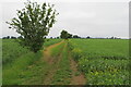
Greensand Ridge Walk footpath
path between freshly cut wheat field and a field awaiting the Combine.
Image: © ian saunders
Taken: 4 Aug 2007
0.16 miles
4
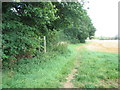
Greensand Ridge Walk footpath
straight ahead is a freshly cut wheat field + Greensand Ridge Walk fp; the footpath sign indicates a footpath junction with the footpath to Cople leading off left. To the right the footpath heads off to Old Warden
Image: © ian saunders
Taken: 4 Aug 2007
0.24 miles