IMAGES TAKEN NEAR TO
Foxglove Gardens, BIGGLESWADE, SG18 9FZ
Introduction
This page details the photographs taken nearby to Foxglove Gardens, SG18 9FZ by members of the Geograph project.
The Geograph project started in 2005 with the aim of publishing, organising and preserving representative images for every square kilometre of Great Britain, Ireland and the Isle of Man.

There are currently over 7.5m images from over14,400 individuals and you can help contribute to the project by visiting https://www.geograph.org.uk
Image Map
Images are licensed for reuse under creativecommons.org/licenses/by-sa/2.0
Notes
- Clicking on the map will re-center to the selected point.
- The higher the marker number, the further away the image location is from the centre of the postcode.
Image Listing (8 Images Found)
Images are licensed for reuse under creativecommons.org/licenses/by-sa/2.0
Image
Details
Distance
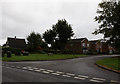
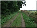
3
Water Lane, Upper Caldecote.
Leads to Waterlane Farm and the common.
Image: © Robin Hall
Taken: 5 Feb 2006
0.10 miles
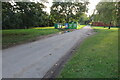
4
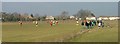
Football at the sports ground.
I have no idea what the score was or who was playing.
Image: © Robin Hall
Taken: 5 Feb 2006
0.13 miles
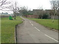
6
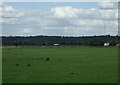
Grazing, Upper Caldecote
Distant view towards the A1.
Image: © JThomas
Taken: 15 Aug 2015
0.19 miles
7
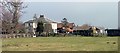
Waterlane Farm
Guinea fowl in the paddock.
Image: © Robin Hall
Taken: 5 Feb 2006
0.19 miles