IMAGES TAKEN NEAR TO
Ewbank Corner, BIGGLESWADE, SG18 9FF
Introduction
This page details the photographs taken nearby to Ewbank Corner, SG18 9FF by members of the Geograph project.
The Geograph project started in 2005 with the aim of publishing, organising and preserving representative images for every square kilometre of Great Britain, Ireland and the Isle of Man.

There are currently over 7.5m images from over14,400 individuals and you can help contribute to the project by visiting https://www.geograph.org.uk
Image Map
Images are licensed for reuse under creativecommons.org/licenses/by-sa/2.0
Notes
- Clicking on the map will re-center to the selected point.
- The higher the marker number, the further away the image location is from the centre of the postcode.
Image Listing (10 Images Found)
Images are licensed for reuse under creativecommons.org/licenses/by-sa/2.0
Image
Details
Distance
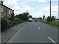
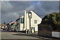
4
Langford Road at the junction of East Road
The mini roundabout is a new arrival in the past year or two before 2012
Image: © David Howard
Taken: 31 May 2012
0.16 miles
5
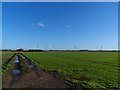
Footpath towards Holme Green
Wind turbines in the background are not yet marked on the O.S. map.
Image: © Bikeboy
Taken: 2 Jan 2014
0.20 miles
8
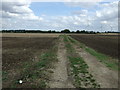
Farm track (Footpath) off Langford Road
Looking east.
Image: © JThomas
Taken: 15 Aug 2015
0.21 miles