IMAGES TAKEN NEAR TO
Tompions End, BIGGLESWADE, SG18 9EN
Introduction
This page details the photographs taken nearby to Tompions End, SG18 9EN by members of the Geograph project.
The Geograph project started in 2005 with the aim of publishing, organising and preserving representative images for every square kilometre of Great Britain, Ireland and the Isle of Man.

There are currently over 7.5m images from over14,400 individuals and you can help contribute to the project by visiting https://www.geograph.org.uk
Image Map
Images are licensed for reuse under creativecommons.org/licenses/by-sa/2.0
Notes
- Clicking on the map will re-center to the selected point.
- The higher the marker number, the further away the image location is from the centre of the postcode.
Image Listing (10 Images Found)
Images are licensed for reuse under creativecommons.org/licenses/by-sa/2.0
Image
Details
Distance
1

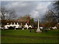
Thatched cottage in Ickwell Green
With boxing hares and aeroplane roof ornaments
Image: © Philip Jeffrey
Taken: 3 Oct 2021
0.12 miles
5
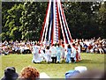
Maypole dancing, Ickwell Green, Bedfordshire
Ickwell May Day
Villagers & Morris-men dancing beside the Maypole on Ickwell Green, soon after dawn on 1 May 2005. The Ickwell May Day festival, first documented in the Churchwardens' accounts of c. 1565 but perhaps originating in the pre-Christian Beltane, takes place on Ickwell Green and celebrates the arrival of spring on May Morning, or 1 May. In the time of the Puritans, the festival ceased. A permanent Maypole was first erected in 1872 by the local squire, John Harvey, to celebrate the birth of his son. There is Morris dancing by the Ickwell Mayers, the Old Scholars dance around the Maypole with their children and grandchildren, and with other games, contests, country dances, and music a May Queen is crowned.(Wikipedia)
Image: © nick macneill
Taken: 1 May 2002
0.21 miles
6
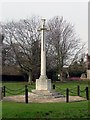
Ickwell War Memorial
Sited at one side of a large village green.
Image: © Robin Hall
Taken: 11 Feb 2006
0.21 miles
7
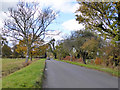
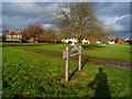
Ickwell Road
Towards Ickwell from Upper Caldecot. It may be Caldecot Road, it is at the Ickwell end. Possibly the name changes at the stream crossing just beyond the car ahead, although there never was a mapped parish or other boundary here.
Image: © Robin Webster
Taken: 12 Nov 2017
0.22 miles

10
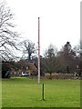
Maypole on Ickwell village green
Large, sturdy and apparently permanent.
Image: © Robin Hall
Taken: 11 Feb 2006
0.25 miles